

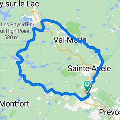
Simon River Road - Lac Renaud Loop
A cycling route starting in Saint-Sauveur, Quebec, Canada.
Overview
About this route
- -:--
- Duration
- 17.1 km
- Distance
- 239 m
- Ascent
- 239 m
- Descent
- ---
- Avg. speed
- ---
- Max. altitude
Route quality
Waytypes & surfaces along the route
Waytypes
Road
17 km
(99 %)
Undefined
0.2 km
(1 %)
Surfaces
Paved
16.5 km
(96 %)
Asphalt
14.4 km
(84 %)
Paved (undefined)
2.1 km
(12 %)
Undefined
0.7 km
(4 %)
Continue with Bikemap
Use, edit, or download this cycling route
You would like to ride Simon River Road - Lac Renaud Loop or customize it for your own trip? Here is what you can do with this Bikemap route:
Free features
- Save this route as favorite or in collections
- Copy & plan your own version of this route
- Sync your route with Garmin or Wahoo
Premium features
Free trial for 3 days, or one-time payment. More about Bikemap Premium.
- Navigate this route on iOS & Android
- Export a GPX / KML file of this route
- Create your custom printout (try it for free)
- Download this route for offline navigation
Discover more Premium features.
Get Bikemap PremiumFrom our community
Other popular routes starting in Saint-Sauveur
 Morin-heights-st-adolphe-ste-agathe-val-david-piedmont-st-sauveur-morin-heights
- Distance
- 67.1 km
- Ascent
- 643 m
- Descent
- 647 m
- Location
- Saint-Sauveur, Quebec, Canada
 40 Km Fun !
- Distance
- 40.9 km
- Ascent
- 357 m
- Descent
- 353 m
- Location
- Saint-Sauveur, Quebec, Canada
 boucle st-sau, lachute, ste anne des lacs
- Distance
- 105.3 km
- Ascent
- 575 m
- Descent
- 575 m
- Location
- Saint-Sauveur, Quebec, Canada
 ssv-st adolphe-ste agathe-ste adele-ssv
- Distance
- 70.6 km
- Ascent
- 913 m
- Descent
- 1,010 m
- Location
- Saint-Sauveur, Quebec, Canada
 un grand tour
- Distance
- 96.9 km
- Ascent
- 937 m
- Descent
- 994 m
- Location
- Saint-Sauveur, Quebec, Canada
 tour du courage CLONED FROM ROUTE 447629
- Distance
- 53.8 km
- Ascent
- 434 m
- Descent
- 434 m
- Location
- Saint-Sauveur, Quebec, Canada
 Boucle Morin-Heights - Milles-Iles
- Distance
- 32.2 km
- Ascent
- 398 m
- Descent
- 396 m
- Location
- Saint-Sauveur, Quebec, Canada
 62 km
62 km- Distance
- 62.9 km
- Ascent
- 436 m
- Descent
- 434 m
- Location
- Saint-Sauveur, Quebec, Canada
Open it in the app