

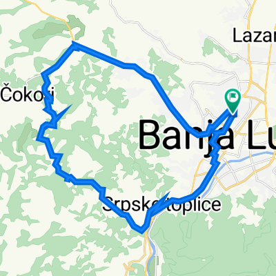
Busnovi
A cycling route starting in Banja Luka, Republika Srpska, Bosnia and Herzegovina.
Overview
About this route
- -:--
- Duration
- 103 km
- Distance
- 428 m
- Ascent
- 429 m
- Descent
- ---
- Avg. speed
- ---
- Max. altitude

Route quality
Waytypes & surfaces along the route
Waytypes
Quiet road
35 km
(34 %)
Road
23.7 km
(23 %)
Surfaces
Paved
80.3 km
(78 %)
Unpaved
6.2 km
(6 %)
Asphalt
70 km
(68 %)
Paved (undefined)
10.3 km
(10 %)
Continue with Bikemap
Use, edit, or download this cycling route
You would like to ride Busnovi or customize it for your own trip? Here is what you can do with this Bikemap route:
Free features
- Save this route as favorite or in collections
- Copy & plan your own version of this route
- Split it into stages to create a multi-day tour
- Sync your route with Garmin or Wahoo
Premium features
Free trial for 3 days, or one-time payment. More about Bikemap Premium.
- Navigate this route on iOS & Android
- Export a GPX / KML file of this route
- Create your custom printout (try it for free)
- Download this route for offline navigation
Discover more Premium features.
Get Bikemap PremiumFrom our community
Other popular routes starting in Banja Luka
 Trive Amelice 1b to Manjačkih Ustanika
- Distance
- 12.2 km
- Ascent
- 177 m
- Descent
- 211 m
- Location
- Banja Luka, Republika Srpska, Bosnia and Herzegovina
 First route.
- Distance
- 12.9 km
- Ascent
- 58 m
- Descent
- 55 m
- Location
- Banja Luka, Republika Srpska, Bosnia and Herzegovina
 Tappa 12 - Banja Luka - Novi Grad
- Distance
- 96.5 km
- Ascent
- 510 m
- Descent
- 542 m
- Location
- Banja Luka, Republika Srpska, Bosnia and Herzegovina
 LSD Day 5 v1.2
- Distance
- 75.7 km
- Ascent
- 1,915 m
- Descent
- 1,736 m
- Location
- Banja Luka, Republika Srpska, Bosnia and Herzegovina
 ruta-tura
- Distance
- 36.1 km
- Ascent
- 83 m
- Descent
- 86 m
- Location
- Banja Luka, Republika Srpska, Bosnia and Herzegovina
 Banja Luka to Banja Luka
- Distance
- 27.3 km
- Ascent
- 476 m
- Descent
- 528 m
- Location
- Banja Luka, Republika Srpska, Bosnia and Herzegovina
 Ponir-Sehovi
- Distance
- 23.4 km
- Ascent
- 567 m
- Descent
- 565 m
- Location
- Banja Luka, Republika Srpska, Bosnia and Herzegovina
 east podgorica banja luka
- Distance
- 485.5 km
- Ascent
- 3,813 m
- Descent
- 3,926 m
- Location
- Banja Luka, Republika Srpska, Bosnia and Herzegovina
Open it in the app