
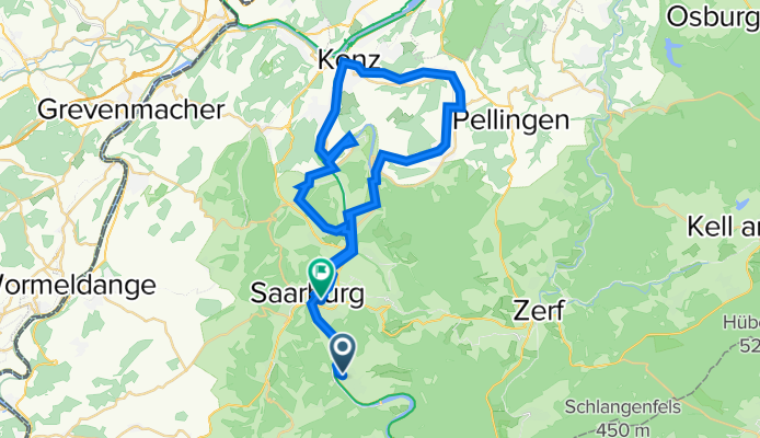
Untere Saar
A cycling route starting in Serrig, Rhineland-Palatinate, Germany.
Overview
About this route
Kleine Runde auf überwiegend verkehrsfreien Wegen
Start und Ziel an Bahnhöfen
- -:--
- Duration
- 43.1 km
- Distance
- 199 m
- Ascent
- 208 m
- Descent
- ---
- Avg. speed
- ---
- Max. altitude

Route quality
Waytypes & surfaces along the route
Waytypes
Path
20.3 km
(47 %)
Quiet road
9 km
(21 %)
Surfaces
Paved
38.4 km
(89 %)
Unpaved
1.3 km
(3 %)
Asphalt
34.9 km
(81 %)
Concrete
2.2 km
(5 %)
Continue with Bikemap
Use, edit, or download this cycling route
You would like to ride Untere Saar or customize it for your own trip? Here is what you can do with this Bikemap route:
Free features
- Save this route as favorite or in collections
- Copy & plan your own version of this route
- Sync your route with Garmin or Wahoo
Premium features
Free trial for 3 days, or one-time payment. More about Bikemap Premium.
- Navigate this route on iOS & Android
- Export a GPX / KML file of this route
- Create your custom printout (try it for free)
- Download this route for offline navigation
Discover more Premium features.
Get Bikemap PremiumFrom our community
Other popular routes starting in Serrig
 RTF Rund um die Saarmündung 2008 des RV Frei Weg Serrig e.V. - 71 km Strecke
- Distance
- 65.6 km
- Ascent
- 530 m
- Descent
- 440 m
- Location
- Serrig, Rhineland-Palatinate, Germany
 RTF Rund um die Saarmündung des RV Frei Weg Serrig e.V. - 110 km Strecke
- Distance
- 110.3 km
- Ascent
- 1,314 m
- Descent
- 1,328 m
- Location
- Serrig, Rhineland-Palatinate, Germany
 Bachtal Runde Serrig
- Distance
- 9.8 km
- Ascent
- 131 m
- Descent
- 128 m
- Location
- Serrig, Rhineland-Palatinate, Germany
 Tour 18 Saarburg Schamat 4 wie 2 l d2
- Distance
- 21.7 km
- Ascent
- 218 m
- Descent
- 214 m
- Location
- Serrig, Rhineland-Palatinate, Germany
 RTF Rund um die Saarmündung 2008 des RV Frei Weg Serrig e.V. - 111 km Strecke
- Distance
- 98.7 km
- Ascent
- 941 m
- Descent
- 942 m
- Location
- Serrig, Rhineland-Palatinate, Germany
 Urlaub 2019
- Distance
- 10.4 km
- Ascent
- 69 m
- Descent
- 56 m
- Location
- Serrig, Rhineland-Palatinate, Germany
 Serrig -Kollesleukrn - Hasenmühle - Weiten - Serrig
- Distance
- 35.5 km
- Ascent
- 357 m
- Descent
- 369 m
- Location
- Serrig, Rhineland-Palatinate, Germany
 Serrig-Ockfen-Irsch-Serrig
- Distance
- 17.7 km
- Ascent
- 256 m
- Descent
- 257 m
- Location
- Serrig, Rhineland-Palatinate, Germany
Open it in the app