

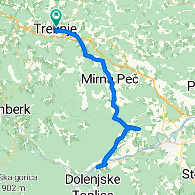
Trebnje Šmarješke toplice Žužemberk Trebnje
A cycling route starting in Trebnje, Trebnje, Slovenia.
Overview
About this route
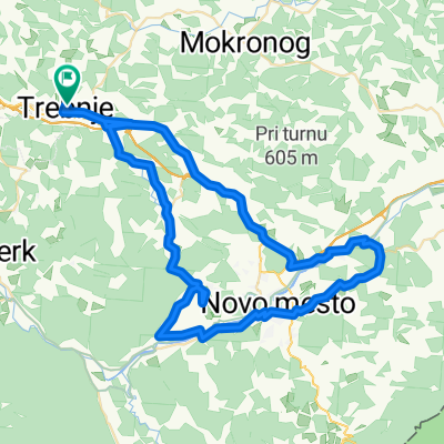
Super hitra proga.
-
Do novega mesta dosti dela pred Mirno pečjo in Šrango
-
Potem lahka vožnja z veliko vrtenja do Zbur
-
V Zburah levo za Mokronog. Vzpon ima rovno pravšnji naklon za hitro vožnjo
-
Od Mokronoga do Trebnjega se kruza
- -:--
- Duration
- 63.1 km
- Distance
- 433 m
- Ascent
- 433 m
- Descent
- ---
- Avg. speed
- ---
- Max. altitude

Route quality
Waytypes & surfaces along the route
Waytypes
Road
24 km
(38 %)
Quiet road
7.6 km
(12 %)
Surfaces
Paved
46.1 km
(73 %)
Asphalt
46.1 km
(73 %)
Undefined
17 km
(27 %)
Continue with Bikemap
Use, edit, or download this cycling route
You would like to ride Trebnje Šmarješke toplice Žužemberk Trebnje or customize it for your own trip? Here is what you can do with this Bikemap route:
Free features
- Save this route as favorite or in collections
- Copy & plan your own version of this route
- Sync your route with Garmin or Wahoo
Premium features
Free trial for 3 days, or one-time payment. More about Bikemap Premium.
- Navigate this route on iOS & Android
- Export a GPX / KML file of this route
- Create your custom printout (try it for free)
- Download this route for offline navigation
Discover more Premium features.
Get Bikemap PremiumFrom our community
Other popular routes starting in Trebnje
 trebnje, mirna peč, vrhovo, straža, prečna, trebnje
- Distance
- 46.5 km
- Ascent
- 406 m
- Descent
- 406 m
- Location
- Trebnje, Trebnje, Slovenia
 trebnje-trebeljevo-grosuplje-trebnje
- Distance
- 80.8 km
- Ascent
- 808 m
- Descent
- 798 m
- Location
- Trebnje, Trebnje, Slovenia
 Obhod dolenjske
- Distance
- 86 km
- Ascent
- 1,743 m
- Descent
- 1,757 m
- Location
- Trebnje, Trebnje, Slovenia
 Trebnje - Šentvid - Trebnje
- Distance
- 36.1 km
- Ascent
- 332 m
- Descent
- 335 m
- Location
- Trebnje, Trebnje, Slovenia
 trebnje-mirna peč
- Distance
- 40 km
- Ascent
- 620 m
- Descent
- 619 m
- Location
- Trebnje, Trebnje, Slovenia
 Trebnje-Šentrupert-Dole pri Litiji-Gabrovka-Čatež-Trebnje
- Distance
- 47 km
- Ascent
- 724 m
- Descent
- 722 m
- Location
- Trebnje, Trebnje, Slovenia
 Trebnje - Otočec - Straža - Mirna Peč -Trebnje
- Distance
- 68 km
- Ascent
- 557 m
- Descent
- 557 m
- Location
- Trebnje, Trebnje, Slovenia
 Kozjak, Ostri vrh
- Distance
- 43.8 km
- Ascent
- 820 m
- Descent
- 820 m
- Location
- Trebnje, Trebnje, Slovenia
Open it in the app