

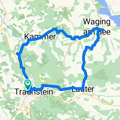
Traunstein um den Chiemsee
A cycling route starting in Traunstein, Bavaria, Germany.
Overview
About this route
- -:--
- Duration
- 66.4 km
- Distance
- 179 m
- Ascent
- 182 m
- Descent
- ---
- Avg. speed
- ---
- Max. altitude

Route quality
Waytypes & surfaces along the route
Waytypes
Quiet road
27.8 km
(42 %)
Track
13.6 km
(20 %)
Surfaces
Paved
46.9 km
(71 %)
Unpaved
17.4 km
(26 %)
Asphalt
46 km
(69 %)
Gravel
13.6 km
(21 %)
Continue with Bikemap
Use, edit, or download this cycling route
You would like to ride Traunstein um den Chiemsee or customize it for your own trip? Here is what you can do with this Bikemap route:
Free features
- Save this route as favorite or in collections
- Copy & plan your own version of this route
- Sync your route with Garmin or Wahoo
Premium features
Free trial for 3 days, or one-time payment. More about Bikemap Premium.
- Navigate this route on iOS & Android
- Export a GPX / KML file of this route
- Create your custom printout (try it for free)
- Download this route for offline navigation
Discover more Premium features.
Get Bikemap PremiumFrom our community
Other popular routes starting in Traunstein
 Brauereitour 2 - Chiemsee und Alz, Hopfen und Malz
- Distance
- 62.7 km
- Ascent
- 608 m
- Descent
- 609 m
- Location
- Traunstein, Bavaria, Germany
 Gut Ising
- Distance
- 16.3 km
- Ascent
- 203 m
- Descent
- 259 m
- Location
- Traunstein, Bavaria, Germany
 Traunstein um Waging am See
- Distance
- 46.6 km
- Ascent
- 418 m
- Descent
- 419 m
- Location
- Traunstein, Bavaria, Germany
 Traunstein-Chieming-Traunstein
- Distance
- 26.3 km
- Ascent
- 210 m
- Descent
- 209 m
- Location
- Traunstein, Bavaria, Germany
 Gut Edermann über Siegsdorf
- Distance
- 43.4 km
- Ascent
- 348 m
- Descent
- 348 m
- Location
- Traunstein, Bavaria, Germany
 Alte Panzerstraße, Traunstein nach Siegerthöhe 2, Trostberg
- Distance
- 22.4 km
- Ascent
- 94 m
- Descent
- 142 m
- Location
- Traunstein, Bavaria, Germany
 Tr3: Traunstein - rund um den Abtsee 73km 447hm
- Distance
- 73 km
- Ascent
- 447 m
- Descent
- 447 m
- Location
- Traunstein, Bavaria, Germany
 Traunstein zum Landhaus Tanner
- Distance
- 34.6 km
- Ascent
- 339 m
- Descent
- 339 m
- Location
- Traunstein, Bavaria, Germany
Open it in the app