

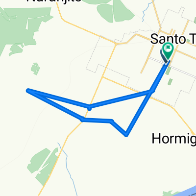
Paseo lento en Santo Tomé
A cycling route starting in Santo Tomé, Corrientes Province, Argentina.
Overview
About this route
- 56 min
- Duration
- 13 km
- Distance
- 72 m
- Ascent
- 70 m
- Descent
- 13.9 km/h
- Avg. speed
- ---
- Max. altitude

Route photos

Route quality
Waytypes & surfaces along the route
Waytypes
Quiet road
5.1 km
(39 %)
Road
0.1 km
(1 %)
Surfaces
Paved
4.9 km
(38 %)
Asphalt
4.8 km
(37 %)
Paved (undefined)
0.1 km
(1 %)
Undefined
8.1 km
(62 %)
Continue with Bikemap
Use, edit, or download this cycling route
You would like to ride Paseo lento en Santo Tomé or customize it for your own trip? Here is what you can do with this Bikemap route:
Free features
- Save this route as favorite or in collections
- Copy & plan your own version of this route
- Sync your route with Garmin or Wahoo
Premium features
Free trial for 3 days, or one-time payment. More about Bikemap Premium.
- Navigate this route on iOS & Android
- Export a GPX / KML file of this route
- Create your custom printout (try it for free)
- Download this route for offline navigation
Discover more Premium features.
Get Bikemap PremiumFrom our community
Other popular routes starting in Santo Tomé
 94mtb
94mtb- Distance
- 26.4 km
- Ascent
- 2,748 m
- Descent
- 2,772 m
- Location
- Santo Tomé, Corrientes Province, Argentina
 Casa-indio
- Distance
- 14.5 km
- Ascent
- 152 m
- Descent
- 115 m
- Location
- Santo Tomé, Corrientes Province, Argentina
 Ruta supersónica en Santo Tomé
- Distance
- 57.6 km
- Ascent
- 359 m
- Descent
- 359 m
- Location
- Santo Tomé, Corrientes Province, Argentina
 De Centeno a Centeno
- Distance
- 19.3 km
- Ascent
- 25 m
- Descent
- 81 m
- Location
- Santo Tomé, Corrientes Province, Argentina
 Ruta a Bertodano 742, Santo Tome
- Distance
- 12.5 km
- Ascent
- 100 m
- Descent
- 101 m
- Location
- Santo Tomé, Corrientes Province, Argentina
 Lunes, 01/06 • Santo Tomé
- Distance
- 58.3 km
- Ascent
- 369 m
- Descent
- 367 m
- Location
- Santo Tomé, Corrientes Province, Argentina
 De Bertrán 22, Corrientes a Independencia 19, Santo Tome
- Distance
- 20.1 km
- Ascent
- 156 m
- Descent
- 157 m
- Location
- Santo Tomé, Corrientes Province, Argentina
 pendiente
- Distance
- 8 km
- Ascent
- 33 m
- Descent
- 24 m
- Location
- Santo Tomé, Corrientes Province, Argentina
Open it in the app