

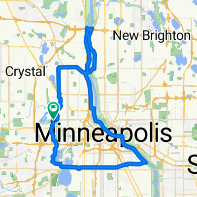
Loop 5/20/20
A cycling route starting in Golden Valley, Minnesota, United States.
Overview
About this route
A lower-intensity route today, biking with a bum right knee. A couple hard hills, including getting into the General Mills Nature Preserve and getting out of that last little park. Took me 46 minutes.
- -:--
- Duration
- 14.8 km
- Distance
- 95 m
- Ascent
- 93 m
- Descent
- ---
- Avg. speed
- ---
- Max. altitude
Route quality
Waytypes & surfaces along the route
Waytypes
Cycleway
8.8 km
(59 %)
Road
3 km
(20 %)
Surfaces
Paved
13.8 km
(93 %)
Asphalt
13.8 km
(93 %)
Undefined
1 km
(7 %)
Continue with Bikemap
Use, edit, or download this cycling route
You would like to ride Loop 5/20/20 or customize it for your own trip? Here is what you can do with this Bikemap route:
Free features
- Save this route as favorite or in collections
- Copy & plan your own version of this route
- Sync your route with Garmin or Wahoo
Premium features
Free trial for 3 days, or one-time payment. More about Bikemap Premium.
- Navigate this route on iOS & Android
- Export a GPX / KML file of this route
- Create your custom printout (try it for free)
- Download this route for offline navigation
Discover more Premium features.
Get Bikemap PremiumFrom our community
Other popular routes starting in Golden Valley
 Luce around Minnetonka
- Distance
- 80 km
- Ascent
- 145 m
- Descent
- 138 m
- Location
- Golden Valley, Minnesota, United States
 edina route66
- Distance
- 46.2 km
- Ascent
- 116 m
- Descent
- 117 m
- Location
- Golden Valley, Minnesota, United States
 B2B00321 55442>55411 via Culver Rd, Kyle Ave, Theo Wirth Pkwy & Plymouth Ave
- Distance
- 5 km
- Ascent
- 37 m
- Descent
- 37 m
- Location
- Golden Valley, Minnesota, United States
 6/28/19
- Distance
- 17.9 km
- Ascent
- 74 m
- Descent
- 77 m
- Location
- Golden Valley, Minnesota, United States
 B2B00649 55411>55344 via Luce Line, Plymouth Rd, Baker Rd
- Distance
- 28.3 km
- Ascent
- 155 m
- Descent
- 160 m
- Location
- Golden Valley, Minnesota, United States
 Theodore Worth to Waconia - <Poor> Parley Lake Rd section
- Distance
- 97.4 km
- Ascent
- 142 m
- Descent
- 142 m
- Location
- Golden Valley, Minnesota, United States
 Theo Wirth Area MTB Trails
- Distance
- 14.8 km
- Ascent
- 81 m
- Descent
- 93 m
- Location
- Golden Valley, Minnesota, United States
 Trip to Wayzata
- Distance
- 18.8 km
- Ascent
- 108 m
- Descent
- 76 m
- Location
- Golden Valley, Minnesota, United States
Open it in the app