

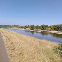
Chassenard - Clermont-Ferrand
A cycling route starting in Molinet, Auvergne-Rhône-Alpes, France.
Overview
About this route
- -:--
- Duration
- 193 km
- Distance
- 395 m
- Ascent
- 294 m
- Descent
- ---
- Avg. speed
- ---
- Max. altitude
Route quality
Waytypes & surfaces along the route
Waytypes
Road
75.3 km
(39 %)
Quiet road
50.2 km
(26 %)
Surfaces
Paved
115.8 km
(60 %)
Unpaved
5.8 km
(3 %)
Asphalt
110 km
(57 %)
Paved (undefined)
3.9 km
(2 %)
Route highlights
Points of interest along the route

Accommodation after 102.2 km
Château de Briailles - Chambre

Accommodation after 192.5 km
La Tour Grégoire
Continue with Bikemap
Use, edit, or download this cycling route
You would like to ride Chassenard - Clermont-Ferrand or customize it for your own trip? Here is what you can do with this Bikemap route:
Free features
- Save this route as favorite or in collections
- Copy & plan your own version of this route
- Split it into stages to create a multi-day tour
- Sync your route with Garmin or Wahoo
Premium features
Free trial for 3 days, or one-time payment. More about Bikemap Premium.
- Navigate this route on iOS & Android
- Export a GPX / KML file of this route
- Create your custom printout (try it for free)
- Download this route for offline navigation
Discover more Premium features.
Get Bikemap PremiumFrom our community
Other popular routes starting in Molinet
 De Grande Rue 11, Saint-Agnan à Place de l'Hôtel de ville 12, Roanne
- Distance
- 83.4 km
- Ascent
- 872 m
- Descent
- 817 m
- Location
- Molinet, Auvergne-Rhône-Alpes, France
 4 Rue de l'Écluse, Chassenard à 5 Rue du 8 Mai 1945, Cuffy
- Distance
- 111.3 km
- Ascent
- 0 m
- Descent
- 0 m
- Location
- Molinet, Auvergne-Rhône-Alpes, France
 De Le Rio Chenet, Molinet à Rue Victor Hugo 23, Digoin
- Distance
- 8.6 km
- Ascent
- 28 m
- Descent
- 21 m
- Location
- Molinet, Auvergne-Rhône-Alpes, France
 Chassenard - Clermont-Ferrand
- Distance
- 193 km
- Ascent
- 395 m
- Descent
- 294 m
- Location
- Molinet, Auvergne-Rhône-Alpes, France
 Chassenard - Decize
- Distance
- 81.1 km
- Ascent
- 315 m
- Descent
- 362 m
- Location
- Molinet, Auvergne-Rhône-Alpes, France
 EuroVelo 6: Molinet to Digoin
- Distance
- 3.6 km
- Ascent
- 13 m
- Descent
- 4 m
- Location
- Molinet, Auvergne-Rhône-Alpes, France
 De La Rue Verte 5, Coulanges à Place des Chambons 3, Coulanges
- Distance
- 31.5 km
- Ascent
- 25 m
- Descent
- 81 m
- Location
- Molinet, Auvergne-Rhône-Alpes, France
 Collanges, Nevers
- Distance
- 104.9 km
- Ascent
- 294 m
- Descent
- 349 m
- Location
- Molinet, Auvergne-Rhône-Alpes, France
Open it in the app