

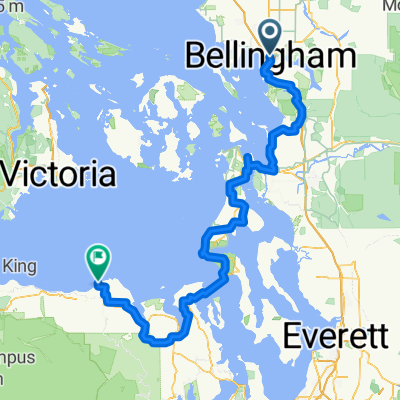
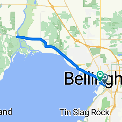
S. Pass/ Mosquito Route
A cycling route starting in Bellingham, Washington, United States.
Overview
About this route
- -:--
- Duration
- 123.1 km
- Distance
- 727 m
- Ascent
- 729 m
- Descent
- ---
- Avg. speed
- ---
- Max. altitude

Route quality
Waytypes & surfaces along the route
Waytypes
Road
75.1 km
(61 %)
Quiet road
19.7 km
(16 %)
Undefined
28.3 km
(23 %)
Surfaces
Paved
38.2 km
(31 %)
Asphalt
38.2 km
(31 %)
Undefined
84.9 km
(69 %)
Continue with Bikemap
Use, edit, or download this cycling route
You would like to ride S. Pass/ Mosquito Route or customize it for your own trip? Here is what you can do with this Bikemap route:
Free features
- Save this route as favorite or in collections
- Copy & plan your own version of this route
- Split it into stages to create a multi-day tour
- Sync your route with Garmin or Wahoo
Premium features
Free trial for 3 days, or one-time payment. More about Bikemap Premium.
- Navigate this route on iOS & Android
- Export a GPX / KML file of this route
- Create your custom printout (try it for free)
- Download this route for offline navigation
Discover more Premium features.
Get Bikemap PremiumFrom our community
Other popular routes starting in Bellingham
 Back roads Birchwood to Birch Bay State Park
- Distance
- 31.8 km
- Ascent
- 205 m
- Descent
- 221 m
- Location
- Bellingham, Washington, United States
 BellinghamTrails-CornwallPark-Waterfront-Chuckanut-Interurban-PipelineTrail-Bloedel-RailroadTrail
- Distance
- 52.1 km
- Ascent
- 353 m
- Descent
- 351 m
- Location
- Bellingham, Washington, United States
 S. Pass/ Mosquito Route
- Distance
- 123.1 km
- Ascent
- 727 m
- Descent
- 729 m
- Location
- Bellingham, Washington, United States
 Kearney St, Bellingham to Voice of America Rd, Sequim
- Distance
- 212.8 km
- Ascent
- 2,840 m
- Descent
- 2,829 m
- Location
- Bellingham, Washington, United States
 10 mile loop
- Distance
- 16.2 km
- Ascent
- 156 m
- Descent
- 158 m
- Location
- Bellingham, Washington, United States
 Commercial Street to C Street
- Distance
- 20.3 km
- Ascent
- 100 m
- Descent
- 111 m
- Location
- Bellingham, Washington, United States
 Bellingham to Snohomish: scenic route
- Distance
- 132.5 km
- Ascent
- 994 m
- Descent
- 952 m
- Location
- Bellingham, Washington, United States
 Bellingham-Ferndale-RedRiver-MariettaLoop
- Distance
- 49.6 km
- Ascent
- 149 m
- Descent
- 149 m
- Location
- Bellingham, Washington, United States
Open it in the app