

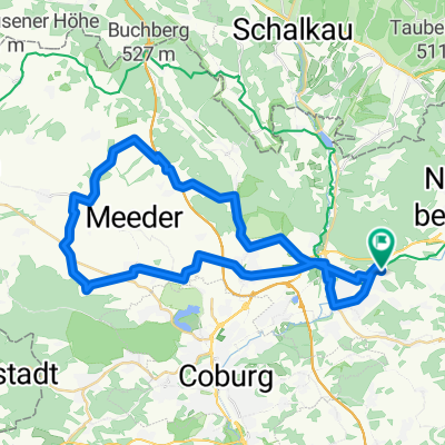
Rund um die Veste Coburg
A cycling route starting in Rödental, Bavaria, Germany.
Overview
About this route
mostly bike paths through picturesque landscapes. Partly along the former border of the two German states. my individual travel time is about 3 hours and 20 minutes. city and countryside alternate.
- -:--
- Duration
- 59.1 km
- Distance
- 213 m
- Ascent
- 213 m
- Descent
- ---
- Avg. speed
- ---
- Max. altitude

Continue with Bikemap
Use, edit, or download this cycling route
You would like to ride Rund um die Veste Coburg or customize it for your own trip? Here is what you can do with this Bikemap route:
Free features
- Save this route as favorite or in collections
- Copy & plan your own version of this route
- Sync your route with Garmin or Wahoo
Premium features
Free trial for 3 days, or one-time payment. More about Bikemap Premium.
- Navigate this route on iOS & Android
- Export a GPX / KML file of this route
- Create your custom printout (try it for free)
- Download this route for offline navigation
Discover more Premium features.
Get Bikemap PremiumFrom our community
Other popular routes starting in Rödental
 Rund um die Veste Coburg
- Distance
- 59.1 km
- Ascent
- 213 m
- Descent
- 213 m
- Location
- Rödental, Bavaria, Germany
 Kleine Runde gegen Pfunde.
- Distance
- 22.8 km
- Ascent
- 135 m
- Descent
- 135 m
- Location
- Rödental, Bavaria, Germany
 Röd-Froschgrundsee-Röd
- Distance
- 19.4 km
- Ascent
- 170 m
- Descent
- 168 m
- Location
- Rödental, Bavaria, Germany
 4Tälerweg -Röden-Itz-Lauter-Rodach
- Distance
- 39.6 km
- Ascent
- 551 m
- Descent
- 554 m
- Location
- Rödental, Bavaria, Germany
 Rund um den Blessberg im Urzeigersinn
- Distance
- 80.6 km
- Ascent
- 1,055 m
- Descent
- 982 m
- Location
- Rödental, Bavaria, Germany
 Rund um die Rosenau
- Distance
- 15.4 km
- Ascent
- 134 m
- Descent
- 134 m
- Location
- Rödental, Bavaria, Germany
 Landkreis Coburg ganz oben (Mirsdorf)
- Distance
- 42.1 km
- Ascent
- 309 m
- Descent
- 324 m
- Location
- Rödental, Bavaria, Germany
 durchs Laudertal und Rödental rund um die Schaumburg
- Distance
- 54.8 km
- Ascent
- 475 m
- Descent
- 475 m
- Location
- Rödental, Bavaria, Germany
Open it in the app