

Renner_Optimal_Wörth-Seemannshsn.-Oberspechtrain-Frontenhsn.-Obertrennbach-Seemannshsn.-Gangkofen-Aham-Wörth
A cycling route starting in Wörth an der Isar, Bavaria, Germany.
Overview
About this route
This is the best way to Seemannshausen! After Obertrennbach, there is a stretch of concrete pavement, not great, but it's manageable.
- -:--
- Duration
- 76.2 km
- Distance
- 745 m
- Ascent
- 743 m
- Descent
- ---
- Avg. speed
- ---
- Max. altitude

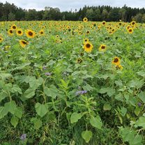
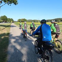
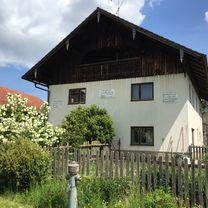
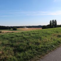
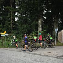
Route photos


Route quality
Waytypes & surfaces along the route
Waytypes
Quiet road
35.8 km
(47 %)
Road
24.4 km
(32 %)
Surfaces
Paved
69.3 km
(91 %)
Asphalt
69.3 km
(91 %)
Undefined
6.9 km
(9 %)
Continue with Bikemap
Use, edit, or download this cycling route
You would like to ride Renner_Optimal_Wörth-Seemannshsn.-Oberspechtrain-Frontenhsn.-Obertrennbach-Seemannshsn.-Gangkofen-Aham-Wörth or customize it for your own trip? Here is what you can do with this Bikemap route:
Free features
- Save this route as favorite or in collections
- Copy & plan your own version of this route
- Sync your route with Garmin or Wahoo
Premium features
Free trial for 3 days, or one-time payment. More about Bikemap Premium.
- Navigate this route on iOS & Android
- Export a GPX / KML file of this route
- Create your custom printout (try it for free)
- Download this route for offline navigation
Discover more Premium features.
Get Bikemap PremiumFrom our community
Other popular routes starting in Wörth an der Isar
 Wörth-Niederviehbach-Gummering-Loiching-Bergham-Teisbach-Oberteisbach-Maßendorf-Weigendorf-Süßbach-Schlott-Gummering-Wörth
- Distance
- 27.9 km
- Ascent
- 292 m
- Descent
- 292 m
- Location
- Wörth an der Isar, Bavaria, Germany
 Mit Marietta ins süße Leben
- Distance
- 35.7 km
- Ascent
- 694 m
- Descent
- 694 m
- Location
- Wörth an der Isar, Bavaria, Germany
 Wörth-Piflas-Flutmulde-Münchnerau-Bruckbergerau-Volkmannsdorf-Moosburger_Stausee-Forster_am_See-Viecht-LA-Piflas-Wörth
- Distance
- 75.5 km
- Ascent
- 104 m
- Descent
- 104 m
- Location
- Wörth an der Isar, Bavaria, Germany
 Renner_Optimal_Wörth-Seemannshsn.-Oberspechtrain-Frontenhsn.-Obertrennbach-Seemannshsn.-Gangkofen-Aham-Wörth
- Distance
- 76.2 km
- Ascent
- 745 m
- Descent
- 743 m
- Location
- Wörth an der Isar, Bavaria, Germany
 Wörth-Niederviehbach-Hattenkofen-Wimpersing-Lichteneck-Otzlberg-Großbettenrain-Triendorf-Postreit-Oberaichbach-Wörth
- Distance
- 34.2 km
- Ascent
- 230 m
- Descent
- 230 m
- Location
- Wörth an der Isar, Bavaria, Germany
 Wörth-Kronwieden-Loiching-Süßbach-Weigendorf-Göttersdorf-Wieselsberg-Otzlberg-Triendorf-Oberaichbach-Niederaichbach-Wörth
- Distance
- 37.4 km
- Ascent
- 328 m
- Descent
- 330 m
- Location
- Wörth an der Isar, Bavaria, Germany
 Wörth-Niederviehbach_Isarbrücke_Kronwieden-Loiching-Schlott-Süßbach-Kirchberg-Setzensack-Adlkofen-Frauenberg-Wolfsbach-Niederaichbach-Wörth
- Distance
- 48.1 km
- Ascent
- 460 m
- Descent
- 460 m
- Location
- Wörth an der Isar, Bavaria, Germany
 Wörth-Kronwieden-Rimbach-Ottending-Hofdorf-Weichshofen-Hüttenkofen-Ottering-Thürntenning-Weng-Postau-Wörth
- Distance
- 53 km
- Ascent
- 332 m
- Descent
- 333 m
- Location
- Wörth an der Isar, Bavaria, Germany
Open it in the app