- 13.3 km
- 277 m
- 277 m
- Witten, North Rhine-Westphalia, Germany
R261b: Rheinischer Esel, Ruhrtalradweg und vier Seen
A cycling route starting in Witten, North Rhine-Westphalia, Germany.
Overview
About this route
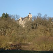
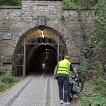
The tour begins on the east shore of Kemnader Lake. We take a quick look at the hills north of Lottental, where the Bochum Ruhr University impressively rises, before we follow the Ölbach past Haus Heven (a manor from the 11th century) to Ümminger Lake. From here, city streets lead us toward and through the Bochum district of Langendreer, where we encounter the railway bike path 'Rheinischer Esel'. We leave Bochum behind and finally have a clear view of the landscape and nature. The Rheinischer Esel takes us with moderate incline past Witten-Annen into the south of the city of Dortmund. Shortly after leaving the Rheinischer Esel, we reach the district of Kirchhörde, where we have to tackle a short but steep ascent (20%) on Kirchhörder Berg. We traverse the Bittermark urban forest, Dortmund's largest contiguous forest area on the northern slope of the Ardey Mountains, and pass the fairways of the Dortmund Golf Club before we have to face another steep climb up into the district of Syburg. Here it's worth a small detour to Hohensyburg, offering a magnificent view of the Ruhr Valley and Hengsteysee. For the efforts of the ascent, the winding descent down Syberg into the Ruhr Valley rewards us where we reach the Ruhrtal cycle path, which constitutes the last stage of our tour. We follow the Ruhrtal cycle path through Herdecke and Wetter, where we cross the Ruhr towards Hagen-Vorhalle. To the left of the Ruhr, we continue through Wetter-Volmarstein and the Witten districts of Wengern, Bommern, and Herbede. In this section, panoramic views over the Ruhr floodplains toward the hills on the other side are frequent. In the area of the Ruhr Viaduct, we see the rugged Hohenstein with the Berger Monument on the opposite side. Meanwhile, the Ruhrtal cycle path runs right next to the track of the RuhrtalBahn. We reach the Nachtigall mine, now a museum with a visitor mine and many exhibits on Ruhr mining and shipping on the Ruhr. Here, you can also access the mining hiking trail through Muttental, the cradle of mining in the Ruhr, with evidence of centuries of Ruhr mining such as tunnels, pingen, headframes, spoil heaps, loading facilities, and more. It's worth taking some time here for an interesting history lesson. Here at the Nachtigall mine we turn right to cross to the other side of the Ruhr via the small Nachtigall bridge (bypassing the bicycle ferry in Herbede in winter). In the summer we can continue straight to the ferry terminal in Herbede and cross the Ruhr with the small Ruhrtal ferry. At the Herbede lock, we briefly enjoy the romantic view of the ruins of Hardenstein Castle and continue on our way downriver towards the Ruhr. Shortly after we arrive at the former Sonnenschein distillery, and we are almost back at the starting point of our exciting tour, Kemnader Lake.
- -:--
- Duration
- 63.2 km
- Distance
- 727 m
- Ascent
- 729 m
- Descent
- ---
- Avg. speed
- 250 m
- Max. altitude
created this 5 years ago
Route photos
Route quality
Waytypes & surfaces along the route
Waytypes
Path
32.9 km
(52 %)
Quiet road
8.8 km
(14 %)
Surfaces
Paved
41.1 km
(65 %)
Unpaved
11.4 km
(18 %)
Asphalt
40.4 km
(64 %)
Gravel
8.2 km
(13 %)
Continue with Bikemap
Use, edit, or download this cycling route
You would like to ride R261b: Rheinischer Esel, Ruhrtalradweg und vier Seen or customize it for your own trip? Here is what you can do with this Bikemap route:
Free features
- Save this route as favorite or in collections
- Copy & plan your own version of this route
- Sync your route with Garmin or Wahoo
Premium features
Free trial for 3 days, or one-time payment. More about Bikemap Premium.
- Navigate this route on iOS & Android
- Export a GPX / KML file of this route
- Create your custom printout (try it for free)
- Download this route for offline navigation
Discover more Premium features.
Get Bikemap PremiumFrom our community
Other popular routes starting in Witten
- Witten-Hohenstein
- Mittlere Route Langendreer - Stockum
- 11.4 km
- 91 m
- 85 m
- Witten, North Rhine-Westphalia, Germany
- Dammstraße nach Vor den Teichen
- 39 km
- 197 m
- 246 m
- Witten, North Rhine-Westphalia, Germany
- Kleine Ruhrrunde
- 52.5 km
- 350 m
- 362 m
- Witten, North Rhine-Westphalia, Germany
- Von Zuhause nach Karl Heinz
- 6.1 km
- 40 m
- 15 m
- Witten, North Rhine-Westphalia, Germany
- Holzkampstraße, Witten nach Holzkampstraße, Witten
- 76.6 km
- 856 m
- 856 m
- Witten, North Rhine-Westphalia, Germany
- RTF, RV Flottweg
- 144.1 km
- 538 m
- 543 m
- Witten, North Rhine-Westphalia, Germany
- In der Lake nach Dibergstraße
- 9.9 km
- 90 m
- 69 m
- Witten, North Rhine-Westphalia, Germany
Open it in the app


