
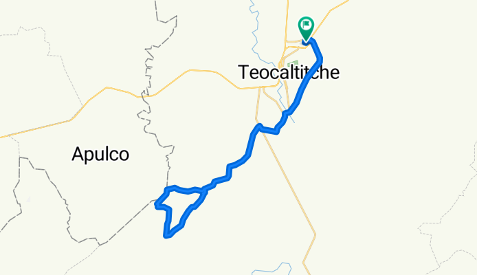
El Cuaite,Santa Bárbara, Teocal.
A cycling route starting in Teocaltiche, Jalisco, Mexico.
Overview
About this route
- 3 h 16 min
- Duration
- 38.6 km
- Distance
- 260 m
- Ascent
- 267 m
- Descent
- 11.8 km/h
- Avg. speed
- ---
- Max. altitude

Route quality
Waytypes & surfaces along the route
Waytypes
Quiet road
27 km
(70 %)
Undefined
11.6 km
(30 %)
Surfaces
Paved
11.6 km
(30 %)
Asphalt
11.6 km
(30 %)
Undefined
27 km
(70 %)
Continue with Bikemap
Use, edit, or download this cycling route
You would like to ride El Cuaite,Santa Bárbara, Teocal. or customize it for your own trip? Here is what you can do with this Bikemap route:
Free features
- Save this route as favorite or in collections
- Copy & plan your own version of this route
- Sync your route with Garmin or Wahoo
Premium features
Free trial for 3 days, or one-time payment. More about Bikemap Premium.
- Navigate this route on iOS & Android
- Export a GPX / KML file of this route
- Create your custom printout (try it for free)
- Download this route for offline navigation
Discover more Premium features.
Get Bikemap PremiumFrom our community
Other popular routes starting in Teocaltiche
 El Paso de la Canoa, Alconero, Las Juntas, Teocal.
- Distance
- 36.1 km
- Ascent
- 411 m
- Descent
- 395 m
- Location
- Teocaltiche, Jalisco, Mexico
 De Avenida Cedros 47, Teocaltiche a Sicomoros 63, Teocaltiche
- Distance
- 100.3 km
- Ascent
- 1,069 m
- Descent
- 1,056 m
- Location
- Teocaltiche, Jalisco, Mexico
 Las 3 Alamedas, Cruz Gorda, Libramiento.
- Distance
- 26 km
- Ascent
- 302 m
- Descent
- 287 m
- Location
- Teocaltiche, Jalisco, Mexico
 El Cuaite,Santa Bárbara, Teocal.
- Distance
- 38.6 km
- Ascent
- 260 m
- Descent
- 267 m
- Location
- Teocaltiche, Jalisco, Mexico
 Calera, Mechoacanejo, San Isidro, Los Yañez, Tepusco, Presa de San Ignacio, Teocal.
- Distance
- 53.9 km
- Ascent
- 636 m
- Descent
- 631 m
- Location
- Teocaltiche, Jalisco, Mexico
 Niños Héroes 733, Teocaltiche a Niños Héroes 607, Teocaltiche
- Distance
- 15.3 km
- Ascent
- 195 m
- Descent
- 213 m
- Location
- Teocaltiche, Jalisco, Mexico
 Villa de Ornelas, La Trinidad, El Tablero, Ciénega de Mora, Crucero del Montecillo, Belén, El Soyatal, El Salitre, Chaneja y Teocal...
- Distance
- 100.3 km
- Ascent
- 1,224 m
- Descent
- 1,226 m
- Location
- Teocaltiche, Jalisco, Mexico
 3 Alamedas, El Canal, Tenayuca, Zac. Agua Tinta, Chaneja, El Salitre, El Soyatal, El Basurero, Belén, La Haciendita, El Pueblito, Alto de Villa de Ornelas y Teo
- Distance
- 101.4 km
- Ascent
- 1,171 m
- Descent
- 1,157 m
- Location
- Teocaltiche, Jalisco, Mexico
Open it in the app