Von Oberau über Ersbergeralm nach Garmisch-Partenkirchen
A cycling route starting in Oberau, Bavaria, Germany.
Overview
About this route
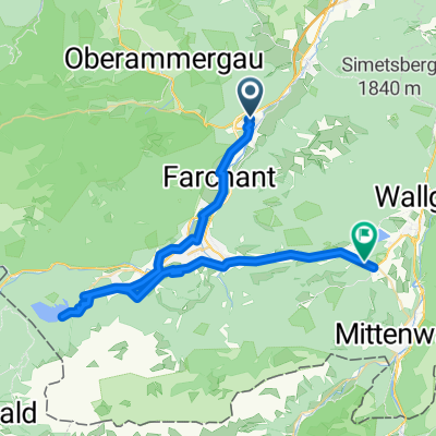
We leave 'Oberau' and ride on the left side of the Loisach. In Eschenlohe, we cross the 'Loisach Bridge' and turn right towards Walchensee through the 'Eschenlaine Valley'. Shortly after the highest point, we turn left and follow the main path. Possibly, we can ride to Walchensee (=> turn right), otherwise towards 'Wallgau'. In Wallgau, turn towards 'Krün, Barmsee'. At the crossroads near Krün, head towards 'Esterberg/Finzbach'. After about 1600 meters, turn right to 'Esterberger Alm'. Here follows the most difficult part, rewarded with a wonderful descent from Esterberger Alm to 'Partenkirchen'.
- -:--
- Duration
- 57.1 km
- Distance
- 921 m
- Ascent
- 865 m
- Descent
- ---
- Avg. speed
- ---
- Max. altitude
Route highlights
Points of interest along the route
Photo after 23.3 km
Wasserwacht
Photo after 45.7 km
Continue with Bikemap
Use, edit, or download this cycling route
You would like to ride Von Oberau über Ersbergeralm nach Garmisch-Partenkirchen or customize it for your own trip? Here is what you can do with this Bikemap route:
Free features
- Save this route as favorite or in collections
- Copy & plan your own version of this route
- Sync your route with Garmin or Wahoo
Premium features
Free trial for 3 days, or one-time payment. More about Bikemap Premium.
- Navigate this route on iOS & Android
- Export a GPX / KML file of this route
- Create your custom printout (try it for free)
- Download this route for offline navigation
Discover more Premium features.
Get Bikemap PremiumFrom our community
Other popular routes starting in Oberau
- Ettaler Sattel
- Distance
- 4.7 km
- Ascent
- 286 m
- Descent
- 63 m
- Location
- Oberau, Bavaria, Germany
- Mühlstraße, Oberau nach Levelingstraße, München
- Distance
- 110.2 km
- Ascent
- 558 m
- Descent
- 687 m
- Location
- Oberau, Bavaria, Germany
- Ettal-Rechtleralm-Esterbergalm
- Distance
- 67.2 km
- Ascent
- 1,779 m
- Descent
- 1,779 m
- Location
- Oberau, Bavaria, Germany
- Von Oberau über Ersbergeralm nach Garmisch-Partenkirchen
- Distance
- 57.1 km
- Ascent
- 921 m
- Descent
- 865 m
- Location
- Oberau, Bavaria, Germany
- Oberau - Murnau - Seeshaupt - Penzberg - Kochel - Oberau
- Distance
- 94.3 km
- Ascent
- 474 m
- Descent
- 492 m
- Location
- Oberau, Bavaria, Germany
- Alpen Oberau Garmisch 2
- Distance
- 11.3 km
- Ascent
- 52 m
- Descent
- 35 m
- Location
- Oberau, Bavaria, Germany
- Oberau - Ammersattel (1105m) - Reutte in Tirol - Nesselwang - Bad Hindelang - Oberjochpass (1178m) - Gaichtpass (1093m) - Namlospass (1359m) - Ehrwald - Garmisc
- Distance
- 214 km
- Ascent
- 3,076 m
- Descent
- 2,832 m
- Location
- Oberau, Bavaria, Germany
- Oberau Radfahren
- Distance
- 0.5 km
- Ascent
- 0 m
- Descent
- 0 m
- Location
- Oberau, Bavaria, Germany
Open it in the app