

Rundtour Oberneukirchen - Mühldorf
A cycling route starting in Oberneukirchen, Bavaria, Germany.
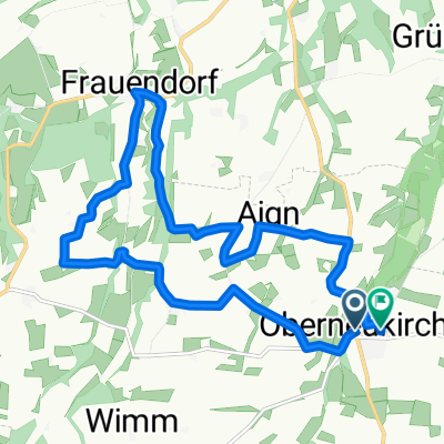
Overview
About this route
Actually, this route via Forsting should lead to the 'Mühldorfer Süden' bike path through Polling to Mühldorf, with a return via Grünbach. However, the signage at the beginning of the route was inadequate and, unfortunately, the bike sign 'Mühldorfer Süden' does not automatically imply that you are on the way to Mühldorf. For this reason, the excursion to Hab, which leads steeply downhill on the return.
- -:--
- Duration
- 28.7 km
- Distance
- 164 m
- Ascent
- 166 m
- Descent
- ---
- Avg. speed
- ---
- Max. altitude

Route quality
Waytypes & surfaces along the route
Waytypes
Quiet road
14.9 km
(52 %)
Road
9.2 km
(32 %)
Surfaces
Paved
26.4 km
(92 %)
Unpaved
1.7 km
(6 %)
Asphalt
26.4 km
(92 %)
Unpaved (undefined)
1.1 km
(4 %)
Continue with Bikemap
Use, edit, or download this cycling route
You would like to ride Rundtour Oberneukirchen - Mühldorf or customize it for your own trip? Here is what you can do with this Bikemap route:
Free features
- Save this route as favorite or in collections
- Copy & plan your own version of this route
- Sync your route with Garmin or Wahoo
Premium features
Free trial for 3 days, or one-time payment. More about Bikemap Premium.
- Navigate this route on iOS & Android
- Export a GPX / KML file of this route
- Create your custom printout (try it for free)
- Download this route for offline navigation
Discover more Premium features.
Get Bikemap PremiumFrom our community
Other popular routes starting in Oberneukirchen
 Langsame Fahrt in Oberneukirchen
- Distance
- 13.6 km
- Ascent
- 131 m
- Descent
- 131 m
- Location
- Oberneukirchen, Bavaria, Germany
 Einfache Fahrt in Mühldorf am Inn
- Distance
- 9.3 km
- Ascent
- 44 m
- Descent
- 48 m
- Location
- Oberneukirchen, Bavaria, Germany
 Langsame Fahrt in Oberneukirchen
- Distance
- 17.6 km
- Ascent
- 68 m
- Descent
- 76 m
- Location
- Oberneukirchen, Bavaria, Germany
 Mühldorf - Kloster Au
- Distance
- 48.5 km
- Ascent
- 538 m
- Descent
- 533 m
- Location
- Oberneukirchen, Bavaria, Germany
 Einfache Fahrt in Oberneukirchen
- Distance
- 19.6 km
- Ascent
- 176 m
- Descent
- 126 m
- Location
- Oberneukirchen, Bavaria, Germany
 80er Testrunde
- Distance
- 81.2 km
- Ascent
- 537 m
- Descent
- 540 m
- Location
- Oberneukirchen, Bavaria, Germany
 Wasser(burg)-Runde
- Distance
- 98.9 km
- Ascent
- 562 m
- Descent
- 558 m
- Location
- Oberneukirchen, Bavaria, Germany
 Kraiburger Straße 39, Polling nach Bräu im Moos Straße 1, Tüßling
- Distance
- 12.7 km
- Ascent
- 42 m
- Descent
- 22 m
- Location
- Oberneukirchen, Bavaria, Germany
Open it in the app