

1. Ring of Kerry
A cycling route starting in Killorglin, Munster, Ireland.
Overview
About this route
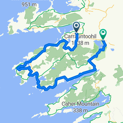
L'anello del Kerry alterna le severità oceaniche di Slea Head ai verdi smeraldini del Parco Nazionale di Killarney. Il nome dell'"anello" è preso dal nome gaelico della contea Ciarraì. Il tour parte dall'entroterra di Killarney, per proseguire verso la deliziosa città di Killorglin che introduce al percorso lungo la costa del Ring of Kerry. Non mancherà la possibilità di una nuotata nelle stupende spiagge intorno a Glenbeigh. L'itinerario prosegue attraverso le città di pescatori di Cahirciveen e Waterville e da qui in poi noterete un cambiamento per quanto riguarda il terreno che diventa più pianeggiante e diminuisce la confusione che contraddistingue le città turistiche di Killarney e Glenbeigh.
Killarney – Glenbeigh 52 km
Glenbeigh – Cahirciveen 27km <br />Cahirciveen – Waterville 30 km<br />Waterville – Sneem 23 km<br />Sneem – Kenmare 16 km<br />Kenmare – Killarney 32 km
- -:--
- Duration
- 190.5 km
- Distance
- 1,003 m
- Ascent
- 981 m
- Descent
- ---
- Avg. speed
- ---
- Max. altitude
Continue with Bikemap
Use, edit, or download this cycling route
You would like to ride 1. Ring of Kerry or customize it for your own trip? Here is what you can do with this Bikemap route:
Free features
- Save this route as favorite or in collections
- Copy & plan your own version of this route
- Split it into stages to create a multi-day tour
- Sync your route with Garmin or Wahoo
Premium features
Free trial for 3 days, or one-time payment. More about Bikemap Premium.
- Navigate this route on iOS & Android
- Export a GPX / KML file of this route
- Create your custom printout (try it for free)
- Download this route for offline navigation
Discover more Premium features.
Get Bikemap PremiumFrom our community
Other popular routes starting in Killorglin
 RingofKerry KK
- Distance
- 211 km
- Ascent
- 1,026 m
- Descent
- 1,026 m
- Location
- Killorglin, Munster, Ireland
 Killorglin to Dingle
- Distance
- 52.9 km
- Ascent
- 292 m
- Descent
- 295 m
- Location
- Killorglin, Munster, Ireland
 2. Killorglin nach Tralee
- Distance
- 146.2 km
- Ascent
- 826 m
- Descent
- 826 m
- Location
- Killorglin, Munster, Ireland
 Caragh Lake route
- Distance
- 41.2 km
- Ascent
- 508 m
- Descent
- 504 m
- Location
- Killorglin, Munster, Ireland
 Ring of Kerry - test
- Distance
- 157.7 km
- Ascent
- 938 m
- Descent
- 938 m
- Location
- Killorglin, Munster, Ireland
 Irland 2002 von Killorglin nach Tralee am 24.09.02
- Distance
- 152.6 km
- Ascent
- 767 m
- Descent
- 781 m
- Location
- Killorglin, Munster, Ireland
 1. Ring of Kerry
- Distance
- 190.5 km
- Ascent
- 1,003 m
- Descent
- 981 m
- Location
- Killorglin, Munster, Ireland
 Skellig Ring
- Distance
- 163.6 km
- Ascent
- 959 m
- Descent
- 961 m
- Location
- Killorglin, Munster, Ireland
Open it in the app