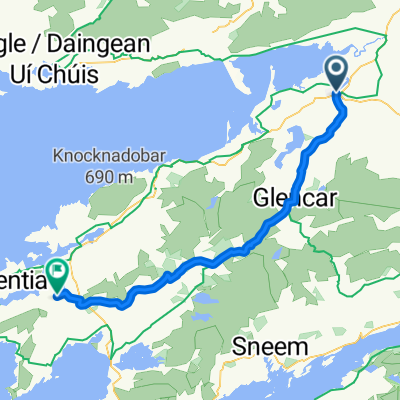
2. Killorglin nach Tralee
A cycling route starting in Killorglin, Munster, Ireland.
Overview
About this route
24.09.02
Killorglin > Inch / Strand > Anascaul > Dingle > Slea Head > Dunquin > Gallarus Oratory > Dingle > Connor Pass > Blennerville > Tralee / Camping
- -:--
- Duration
- 146.2 km
- Distance
- 826 m
- Ascent
- 826 m
- Descent
- ---
- Avg. speed
- ---
- Max. altitude
Route quality
Waytypes & surfaces along the route
Waytypes
Busy road
127.2 km
(87 %)
Quiet road
10.3 km
(7 %)
Surfaces
Paved
71.4 km
(49 %)
Unpaved
1.3 km
(<1 %)
Asphalt
71 km
(49 %)
Ground
0.7 km
(<1 %)
Continue with Bikemap
Use, edit, or download this cycling route
You would like to ride 2. Killorglin nach Tralee or customize it for your own trip? Here is what you can do with this Bikemap route:
Free features
- Save this route as favorite or in collections
- Copy & plan your own version of this route
- Split it into stages to create a multi-day tour
- Sync your route with Garmin or Wahoo
Premium features
Free trial for 3 days, or one-time payment. More about Bikemap Premium.
- Navigate this route on iOS & Android
- Export a GPX / KML file of this route
- Create your custom printout (try it for free)
- Download this route for offline navigation
Discover more Premium features.
Get Bikemap PremiumFrom our community
Other popular routes starting in Killorglin
- cromane caragh lake kilorglin
- Distance
- 42 km
- Ascent
- 519 m
- Descent
- 520 m
- Location
- Killorglin, Munster, Ireland
- Ring of Kerry - test
- Distance
- 157.7 km
- Ascent
- 938 m
- Descent
- 938 m
- Location
- Killorglin, Munster, Ireland
- Irland 2002 von Killorglin nach Tralee am 24.09.02
- Distance
- 152.6 km
- Ascent
- 767 m
- Descent
- 781 m
- Location
- Killorglin, Munster, Ireland
- Skellig Ring
- Distance
- 163.6 km
- Ascent
- 959 m
- Descent
- 961 m
- Location
- Killorglin, Munster, Ireland
- 2. Killorglin nach Tralee
- Distance
- 146.2 km
- Ascent
- 826 m
- Descent
- 826 m
- Location
- Killorglin, Munster, Ireland
- Trail magazine Spring 2022– Carrauntoohil, Ireland
- Distance
- 15 km
- Ascent
- 0 m
- Descent
- 0 m
- Location
- Killorglin, Munster, Ireland
- Caragh Lake route
- Distance
- 41.2 km
- Ascent
- 508 m
- Descent
- 504 m
- Location
- Killorglin, Munster, Ireland
- Killorglin to Dingle
- Distance
- 52.9 km
- Ascent
- 292 m
- Descent
- 295 m
- Location
- Killorglin, Munster, Ireland
Open it in the app