

7 ote san miguel , villa san jose, copoya. san miguel.
A cycling route starting in Copoya, Chiapas, Mexico.
Overview
About this route
- 50 min
- Duration
- 10.9 km
- Distance
- 124 m
- Ascent
- 77 m
- Descent
- 13 km/h
- Avg. speed
- ---
- Max. altitude

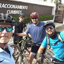
Route photos


Route quality
Waytypes & surfaces along the route
Waytypes
Quiet road
10 km
(92 %)
Road
0.8 km
(7 %)
Undefined
0.1 km
(1 %)
Surfaces
Paved
0.2 km
(2 %)
Unpaved
0.9 km
(8 %)
Unpaved (undefined)
0.9 km
(8 %)
Asphalt
0.2 km
(2 %)
Undefined
9.8 km
(90 %)
Continue with Bikemap
Use, edit, or download this cycling route
You would like to ride 7 ote san miguel , villa san jose, copoya. san miguel. or customize it for your own trip? Here is what you can do with this Bikemap route:
Free features
- Save this route as favorite or in collections
- Copy & plan your own version of this route
- Sync your route with Garmin or Wahoo
Premium features
Free trial for 3 days, or one-time payment. More about Bikemap Premium.
- Navigate this route on iOS & Android
- Export a GPX / KML file of this route
- Create your custom printout (try it for free)
- Download this route for offline navigation
Discover more Premium features.
Get Bikemap PremiumFrom our community
Other popular routes starting in Copoya
 De Boulevard Real del Bosque, Tuxtla Gutiérrez a Calle de los Naranjos 204, Tuxtla Gutiérrez
- Distance
- 0.3 km
- Ascent
- 4 m
- Descent
- 0 m
- Location
- Copoya, Chiapas, Mexico
 san miguel campo de tiro piedra santa. san miguel
- Distance
- 4.2 km
- Ascent
- 41 m
- Descent
- 42 m
- Location
- Copoya, Chiapas, Mexico
 Cereza del pastel
- Distance
- 25.5 km
- Ascent
- 912 m
- Descent
- 934 m
- Location
- Copoya, Chiapas, Mexico
 Ruta deportiva en Chiapa de Corzo
- Distance
- 18.7 km
- Ascent
- 94 m
- Descent
- 180 m
- Location
- Copoya, Chiapas, Mexico
 tuxtla
- Distance
- 85.9 km
- Ascent
- 973 m
- Descent
- 1,414 m
- Location
- Copoya, Chiapas, Mexico
 De Calle 2 21, Tuxtla Gutiérrez a Sándalo Norte 404A, Tuxtla Gutiérrez
- Distance
- 15.4 km
- Ascent
- 61 m
- Descent
- 115 m
- Location
- Copoya, Chiapas, Mexico
 De De La Lanza, Tuxtla Gutiérrez a Cerrada 14a. Poniente Sur 1374, Tuxtla Gutiérrez
- Distance
- 14.8 km
- Ascent
- 222 m
- Descent
- 182 m
- Location
- Copoya, Chiapas, Mexico
 san Cris
- Distance
- 69.2 km
- Ascent
- 2,778 m
- Descent
- 1,242 m
- Location
- Copoya, Chiapas, Mexico
Open it in the app