

TANCHES POUSSIN
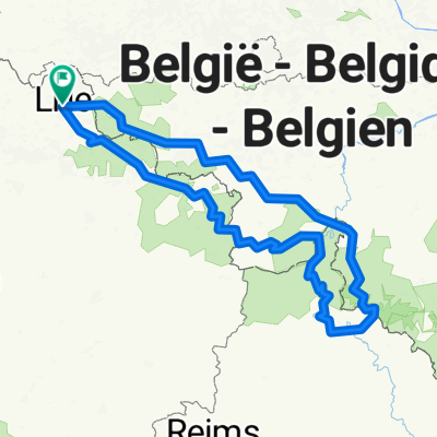
A cycling route starting in Lille, Hauts-de-France, France.
Overview
About this route
Saturday / Sunday / Monday / Tuesday
60 to 80 km per day for a total of: 280 km of pure pleasure.
Section 1: Lille > Saint Amand (Km 70 > 90)
First part: crossing the countryside of Pévèles and Weppes > charming small village atmosphere, floral garden trophy
Second part: discovery of the town of Saint Amand and then the CONDÉ SUR L'ESCAUT REGIONAL NATURAL PARK > atmosphere of forest, streams, ponds, and marshes > small slag heap for the brave (slag heap 74 in the middle of the black dike)
Section 2: Saint Amand > Pont à Vendin (Km 140 > 150)
Mixed terrain between: small village / greenway of the Scapre / canals of the Scapre > small slag heap at the end of the route for the brave (slag heaps 110 / 70 of Oignies) Passing in front of the Pont à Vendin town hall and stop at the WINGLE chip shop km 155
Section 3: Pont à Vendin > Saint Omer (Km 220 > 230)
Day OF CHOICE, between Osillet, the villages around the Lys, OR taking the greenway of the Lys (according to our mood at the moment)
First part: Small village OR follow the Lys / greenway Middle: "central" crossing of the MORBECQUE forest Second part: Small village OR resume the Lys / greenway Arrival: Discovery of Saint Omer, its marshes, canals and ponds.
Section 4: Saint Omer > Lille (Km 280) The Flanders we love so much. Pause at Armentières before a gentle return to reality <3
- -:--
- Duration
- 280.6 km
- Distance
- 747 m
- Ascent
- 748 m
- Descent
- ---
- Avg. speed
- ---
- Max. altitude
Route quality
Waytypes & surfaces along the route
Waytypes
Road
95.4 km
(34 %)
Quiet road
89.8 km
(32 %)
Surfaces
Paved
126.3 km
(45 %)
Unpaved
25.3 km
(9 %)
Asphalt
123.5 km
(44 %)
Gravel
22.4 km
(8 %)
Continue with Bikemap
Use, edit, or download this cycling route
You would like to ride TANCHES POUSSIN or customize it for your own trip? Here is what you can do with this Bikemap route:
Free features
- Save this route as favorite or in collections
- Copy & plan your own version of this route
- Split it into stages to create a multi-day tour
- Sync your route with Garmin or Wahoo
Premium features
Free trial for 3 days, or one-time payment. More about Bikemap Premium.
- Navigate this route on iOS & Android
- Export a GPX / KML file of this route
- Create your custom printout (try it for free)
- Download this route for offline navigation
Discover more Premium features.
Get Bikemap PremiumFrom our community
Other popular routes starting in Lille
 Lille-BPF Merville
- Distance
- 75.7 km
- Ascent
- 75 m
- Descent
- 73 m
- Location
- Lille, Hauts-de-France, France
 Boucle de Test Lille-Lille
- Distance
- 85.5 km
- Ascent
- 131 m
- Descent
- 129 m
- Location
- Lille, Hauts-de-France, France
 Baisieux - Bouillon - Haybes - Orchies - 2015-08 - back-up
- Distance
- 572.5 km
- Ascent
- 1,049 m
- Descent
- 1,055 m
- Location
- Lille, Hauts-de-France, France
 gravel test
- Distance
- 52.8 km
- Ascent
- 96 m
- Descent
- 112 m
- Location
- Lille, Hauts-de-France, France
 MONS-EN-PÉVÈLE
- Distance
- 71 km
- Ascent
- 181 m
- Descent
- 181 m
- Location
- Lille, Hauts-de-France, France
 0 - Baisieux - Bouillon - Haybes - Orchies - 2015-08
- Distance
- 575.3 km
- Ascent
- 982 m
- Descent
- 983 m
- Location
- Lille, Hauts-de-France, France
 Golf de Bondues 02
- Distance
- 41.1 km
- Ascent
- 62 m
- Descent
- 60 m
- Location
- Lille, Hauts-de-France, France
 TANCHES POUSSIN
- Distance
- 280.6 km
- Ascent
- 747 m
- Descent
- 748 m
- Location
- Lille, Hauts-de-France, France
Open it in the app