

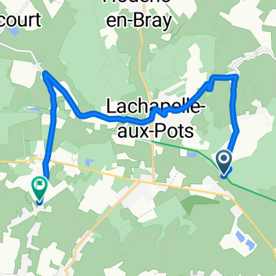
wallembray_mogneville
A cycling route starting in Lachapelle-aux-Pots, Hauts-de-France, France.
Overview
About this route
- -:--
- Duration
- 61 km
- Distance
- 223 m
- Ascent
- 294 m
- Descent
- ---
- Avg. speed
- ---
- Max. altitude

Route quality
Waytypes & surfaces along the route
Waytypes
Quiet road
27.2 km
(45 %)
Road
15 km
(25 %)
Surfaces
Paved
28.6 km
(47 %)
Unpaved
2.6 km
(4 %)
Asphalt
28.4 km
(47 %)
Gravel
1.4 km
(2 %)
Continue with Bikemap
Use, edit, or download this cycling route
You would like to ride wallembray_mogneville or customize it for your own trip? Here is what you can do with this Bikemap route:
Free features
- Save this route as favorite or in collections
- Copy & plan your own version of this route
- Sync your route with Garmin or Wahoo
Premium features
Free trial for 3 days, or one-time payment. More about Bikemap Premium.
- Navigate this route on iOS & Android
- Export a GPX / KML file of this route
- Create your custom printout (try it for free)
- Download this route for offline navigation
Discover more Premium features.
Get Bikemap PremiumFrom our community
Other popular routes starting in Lachapelle-aux-Pots
 De D1, Villembray à 2 Rue du Baron de Giresse, Blacourt
- Distance
- 3.2 km
- Ascent
- 32 m
- Descent
- 77 m
- Location
- Lachapelle-aux-Pots, Hauts-de-France, France
 De Avenue Tristan Klingsor 45, Lachapelle-aux-Pots à Rue des Fauvettes 5, Lachapelle-aux-Pots
- Distance
- 25.8 km
- Ascent
- 100 m
- Descent
- 101 m
- Location
- Lachapelle-aux-Pots, Hauts-de-France, France
 3 Rue des Joncquières, Lachapelle-aux-Pots à 81 Rue de la Gare, Auneuil
- Distance
- 17.2 km
- Ascent
- 89 m
- Descent
- 45 m
- Location
- Lachapelle-aux-Pots, Hauts-de-France, France
 20 Route Nationale, Saint-Aubin-en-Bray to 4 Rue de l'Église, Bornel
- Distance
- 49 km
- Ascent
- 671 m
- Descent
- 728 m
- Location
- Lachapelle-aux-Pots, Hauts-de-France, France
 De Route D Héricourt à Rue des Clos
- Distance
- 10 km
- Ascent
- 121 m
- Descent
- 147 m
- Location
- Lachapelle-aux-Pots, Hauts-de-France, France
 19bis Rue de la Pâture Sèche, Lachapelle-aux-Pots to Square Jules Brière, Beauvais
- Distance
- 17.4 km
- Ascent
- 35 m
- Descent
- 72 m
- Location
- Lachapelle-aux-Pots, Hauts-de-France, France
 De Rue des Prés 11B, Lachapelle-aux-Pots à Rue des Solons 31, Cuigy-en-Bray
- Distance
- 62.3 km
- Ascent
- 26 m
- Descent
- 12 m
- Location
- Lachapelle-aux-Pots, Hauts-de-France, France
 Relaxed route in Ferrières-en-Bray
- Distance
- 14.1 km
- Ascent
- 40 m
- Descent
- 32 m
- Location
- Lachapelle-aux-Pots, Hauts-de-France, France
Open it in the app