

ForcelleAurine-ForcellaFranche-viaMis.2020-05-23
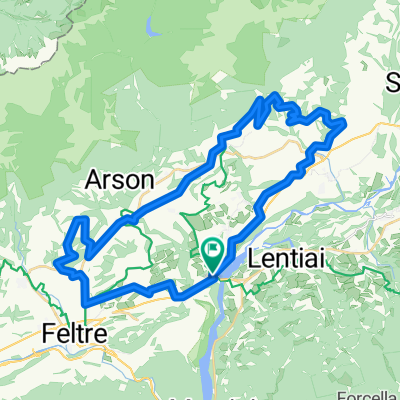
A cycling route starting in Lentiai, Veneto, Italy.
Overview
About this route
Orario inizio: 13:08 23 mag 2020 Orario fine: 18:13 23 mag 2020 Distanza: 98 km (05:04) Tempo movimento: 04:43 Velocità media: 19,3 km/h Velocità media mov.: 20,72 km/h Max. Velocità: 58,86 km/h Altitudine minima: 234 m Altitudine massima: 1287 m Velocità di salita: 648,6 m/h Velocità di discesa: -958,7 m/h Dislivello positivo: 1907 m Dislivello negativo: -1885 m Tempo di salita: 02:56 Tempo di discesa: 01:57
- -:--
- Duration
- 94.5 km
- Distance
- 2,810 m
- Ascent
- 2,812 m
- Descent
- ---
- Avg. speed
- ---
- Max. altitude
Route quality
Waytypes & surfaces along the route
Waytypes
Road
50.1 km
(53 %)
Quiet road
9.5 km
(10 %)
Surfaces
Paved
80.3 km
(85 %)
Asphalt
80.3 km
(85 %)
Undefined
14.2 km
(15 %)
Continue with Bikemap
Use, edit, or download this cycling route
You would like to ride ForcelleAurine-ForcellaFranche-viaMis.2020-05-23 or customize it for your own trip? Here is what you can do with this Bikemap route:
Free features
- Save this route as favorite or in collections
- Copy & plan your own version of this route
- Split it into stages to create a multi-day tour
- Sync your route with Garmin or Wahoo
Premium features
Free trial for 3 days, or one-time payment. More about Bikemap Premium.
- Navigate this route on iOS & Android
- Export a GPX / KML file of this route
- Create your custom printout (try it for free)
- Download this route for offline navigation
Discover more Premium features.
Get Bikemap PremiumFrom our community
Other popular routes starting in Lentiai
 Lago della Stua, via Pullir
- Distance
- 14.5 km
- Ascent
- 642 m
- Descent
- 197 m
- Location
- Lentiai, Veneto, Italy
 Giro-Val-Belluna
- Distance
- 62 km
- Ascent
- 423 m
- Descent
- 423 m
- Location
- Lentiai, Veneto, Italy
 Feltre-Valdobiadene-San Boldo-Feltre-Primiero
- Distance
- 114.7 km
- Ascent
- 1,326 m
- Descent
- 939 m
- Location
- Lentiai, Veneto, Italy
 Bardies-Grappa-Bardies
- Distance
- 102.5 km
- Ascent
- 1,945 m
- Descent
- 1,945 m
- Location
- Lentiai, Veneto, Italy
 ventoux
- Distance
- 1,218.4 km
- Ascent
- 3,827 m
- Descent
- 3,759 m
- Location
- Lentiai, Veneto, Italy
 giro di Busche
- Distance
- 44.4 km
- Ascent
- 670 m
- Descent
- 670 m
- Location
- Lentiai, Veneto, Italy
 ForcelleAurine-ForcellaFranche-viaMis.2020-05-23
- Distance
- 94.5 km
- Ascent
- 2,810 m
- Descent
- 2,812 m
- Location
- Lentiai, Veneto, Italy
 Stabie da Ronchena
- Distance
- 3.1 km
- Ascent
- 289 m
- Descent
- 15 m
- Location
- Lentiai, Veneto, Italy
Open it in the app