

De ¿œM?? a ¿œM??
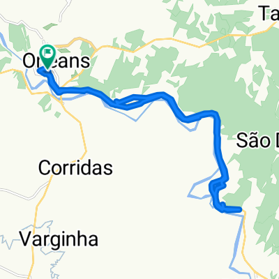
A cycling route starting in Orleans, Santa Catarina, Brazil.
Overview
About this route
- 1 h 19 min
- Duration
- 15.8 km
- Distance
- 117 m
- Ascent
- 122 m
- Descent
- 12.1 km/h
- Avg. speed
- ---
- Max. altitude

Route quality
Waytypes & surfaces along the route
Waytypes
Quiet road
2.5 km
(16 %)
Road
1.3 km
(8 %)
Undefined
12 km
(76 %)
Surfaces
Paved
13.6 km
(86 %)
Asphalt
13.6 km
(86 %)
Undefined
2.2 km
(14 %)
Continue with Bikemap
Use, edit, or download this cycling route
You would like to ride De ¿œM?? a ¿œM?? or customize it for your own trip? Here is what you can do with this Bikemap route:
Free features
- Save this route as favorite or in collections
- Copy & plan your own version of this route
- Sync your route with Garmin or Wahoo
Premium features
Free trial for 3 days, or one-time payment. More about Bikemap Premium.
- Navigate this route on iOS & Android
- Export a GPX / KML file of this route
- Create your custom printout (try it for free)
- Download this route for offline navigation
Discover more Premium features.
Get Bikemap PremiumFrom our community
Other popular routes starting in Orleans
 Volta das serras catarinenses
- Distance
- 223 km
- Ascent
- 2,672 m
- Descent
- 2,668 m
- Location
- Orleans, Santa Catarina, Brazil
 Passeio 30 anos Museu Orlenas
- Distance
- 78.8 km
- Ascent
- 883 m
- Descent
- 959 m
- Location
- Orleans, Santa Catarina, Brazil
 De Rua Leopoldina Antunes Dalmasso, 2–138, Orleans a Rua Leopoldina Antunes Dalmasso, 2–138, Orleans
- Distance
- 18.9 km
- Ascent
- 2,014 m
- Descent
- 2,024 m
- Location
- Orleans, Santa Catarina, Brazil
 orleans - lages
- Distance
- 73.9 km
- Ascent
- 1,817 m
- Descent
- 553 m
- Location
- Orleans, Santa Catarina, Brazil
 De ¿œM?? a ¿œM??
- Distance
- 15.8 km
- Ascent
- 117 m
- Descent
- 122 m
- Location
- Orleans, Santa Catarina, Brazil
 Murialdo to SC-108 4080
- Distance
- 504.7 km
- Ascent
- 11,258 m
- Descent
- 11,187 m
- Location
- Orleans, Santa Catarina, Brazil
 De Rua Leite Ribeiro, 562–752, Orleans a Rua Hugo Carlos Clauman, 2–354, Orleans
- Distance
- 29.6 km
- Ascent
- 727 m
- Descent
- 723 m
- Location
- Orleans, Santa Catarina, Brazil
 Pedal TOP Serra Rio do Rastro #Strava #RideWithUs #NQSF #SantaCatarina
- Distance
- 79.5 km
- Ascent
- 1,532 m
- Descent
- 1,533 m
- Location
- Orleans, Santa Catarina, Brazil
Open it in the app