

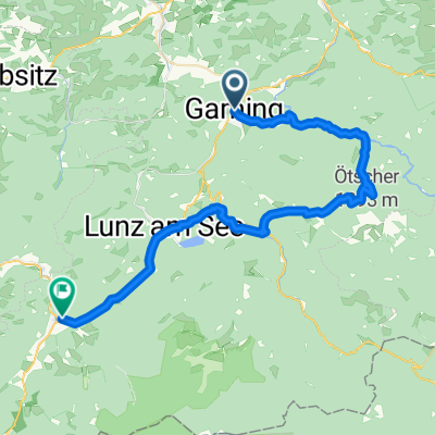
Kombitour 21 & 25
A cycling route starting in Gaming, Lower Austria, Austria.
Overview
About this route
Nestelberg & Steingrabenkreuz MTB route
- -:--
- Duration
- 30.8 km
- Distance
- 1,208 m
- Ascent
- 1,191 m
- Descent
- ---
- Avg. speed
- ---
- Max. altitude

Route quality
Waytypes & surfaces along the route
Waytypes
Quiet road
14.5 km
(47 %)
Track
13.9 km
(45 %)
Surfaces
Paved
16.6 km
(54 %)
Unpaved
13.2 km
(43 %)
Asphalt
12 km
(39 %)
Gravel
11.4 km
(37 %)
Continue with Bikemap
Use, edit, or download this cycling route
You would like to ride Kombitour 21 & 25 or customize it for your own trip? Here is what you can do with this Bikemap route:
Free features
- Save this route as favorite or in collections
- Copy & plan your own version of this route
- Sync your route with Garmin or Wahoo
Premium features
Free trial for 3 days, or one-time payment. More about Bikemap Premium.
- Navigate this route on iOS & Android
- Export a GPX / KML file of this route
- Create your custom printout (try it for free)
- Download this route for offline navigation
Discover more Premium features.
Get Bikemap PremiumFrom our community
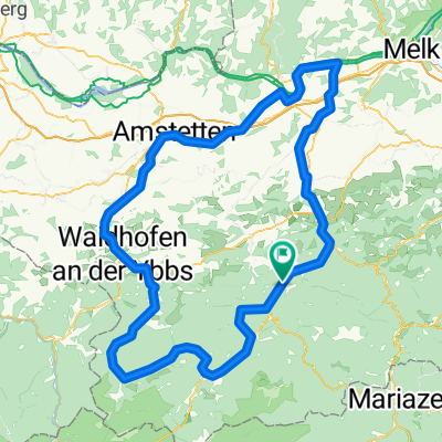
Other popular routes starting in Gaming
 2019-06-09_Lackenhof-Hofstetten(Pielachtal)
- Distance
- 83.6 km
- Ascent
- 564 m
- Descent
- 1,055 m
- Location
- Gaming, Lower Austria, Austria
 Kombitour 21 & 25
- Distance
- 30.8 km
- Ascent
- 1,208 m
- Descent
- 1,191 m
- Location
- Gaming, Lower Austria, Austria
 Ötscher Trekking-Route
- Distance
- 81.8 km
- Ascent
- 1,696 m
- Descent
- 1,696 m
- Location
- Gaming, Lower Austria, Austria
 Baumblütenrunde
- Distance
- 71.5 km
- Ascent
- 2,078 m
- Descent
- 2,075 m
- Location
- Gaming, Lower Austria, Austria
 Ybbstalrunde
- Distance
- 93.8 km
- Ascent
- 1,980 m
- Descent
- 1,975 m
- Location
- Gaming, Lower Austria, Austria
 Gaming - Göstling über Lackenhof
- Distance
- 43.1 km
- Ascent
- 731 m
- Descent
- 629 m
- Location
- Gaming, Lower Austria, Austria
 Kienberg
- Distance
- 35.8 km
- Ascent
- 285 m
- Descent
- 286 m
- Location
- Gaming, Lower Austria, Austria
 Ybbstalerradweg & Ötscherlandradweg
- Distance
- 171.8 km
- Ascent
- 529 m
- Descent
- 528 m
- Location
- Gaming, Lower Austria, Austria
Open it in the app