
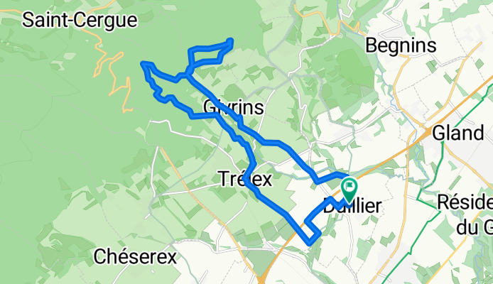
Duillier -Trelex - bas de la chevrerie
A cycling route starting in Trélex, Canton of Vaud, Switzerland.
Overview
About this route
- 1 h 11 min
- Duration
- 18.4 km
- Distance
- 532 m
- Ascent
- 530 m
- Descent
- 15.4 km/h
- Avg. speed
- ---
- Avg. speed
Route quality
Waytypes & surfaces along the route
Waytypes
Track
6.7 km
(37 %)
Quiet road
5.4 km
(29 %)
Surfaces
Paved
2.6 km
(14 %)
Unpaved
5.8 km
(32 %)
Gravel
3.7 km
(20 %)
Asphalt
1.9 km
(10 %)
Continue with Bikemap
Use, edit, or download this cycling route
You would like to ride Duillier -Trelex - bas de la chevrerie or customize it for your own trip? Here is what you can do with this Bikemap route:
Free features
- Save this route as favorite or in collections
- Copy & plan your own version of this route
- Sync your route with Garmin or Wahoo
Premium features
Free trial for 3 days, or one-time payment. More about Bikemap Premium.
- Navigate this route on iOS & Android
- Export a GPX / KML file of this route
- Create your custom printout (try it for free)
- Download this route for offline navigation
Discover more Premium features.
Get Bikemap PremiumFrom our community
Other popular routes starting in Trélex
 De Chemin de la Gâchette 39, Trélex à Chemin de la Gâchette 39, Trélex
- Distance
- 29.7 km
- Ascent
- 733 m
- Descent
- 728 m
- Location
- Trélex, Canton of Vaud, Switzerland
 La Baudichonne
- Distance
- 26.8 km
- Ascent
- 1,028 m
- Descent
- 1,028 m
- Location
- Trélex, Canton of Vaud, Switzerland
 Course La Barillette 2009
- Distance
- 31.5 km
- Ascent
- 1,525 m
- Descent
- 573 m
- Location
- Trélex, Canton of Vaud, Switzerland
 sortie depuis Duillier jusque sur les haut de Givrins
- Distance
- 17.9 km
- Ascent
- 517 m
- Descent
- 517 m
- Location
- Trélex, Canton of Vaud, Switzerland
 Col de la Givrine
- Distance
- 42.2 km
- Ascent
- 1,017 m
- Descent
- 1,017 m
- Location
- Trélex, Canton of Vaud, Switzerland
 Signy-Aubonne-and-back
- Distance
- 47 km
- Ascent
- 288 m
- Descent
- 288 m
- Location
- Trélex, Canton of Vaud, Switzerland
 28 Sep 2014 10:20
- Distance
- 15.1 km
- Ascent
- 565 m
- Descent
- 607 m
- Location
- Trélex, Canton of Vaud, Switzerland
 Exercising Hills
- Distance
- 15.2 km
- Ascent
- 581 m
- Descent
- 582 m
- Location
- Trélex, Canton of Vaud, Switzerland
Open it in the app