

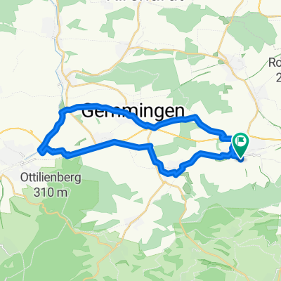
Heuchelberger Warte: Erlebnispfad
A cycling route starting in Schwaigern, Baden-Wurttemberg, Germany.
Overview
About this route
Starting point: Nordheim - K2077 or Leingarten - Auf dem Heuchelberg
- -:--
- Duration
- 3.5 km
- Distance
- 41 m
- Ascent
- 40 m
- Descent
- ---
- Avg. speed
- ---
- Max. altitude

Route quality
Waytypes & surfaces along the route
Waytypes
Path
1.7 km
(49 %)
Track
1.6 km
(46 %)
Surfaces
Paved
0.7 km
(20 %)
Unpaved
1.8 km
(50 %)
Gravel
1.5 km
(42 %)
Asphalt
0.7 km
(20 %)
Continue with Bikemap
Use, edit, or download this cycling route
You would like to ride Heuchelberger Warte: Erlebnispfad or customize it for your own trip? Here is what you can do with this Bikemap route:
Free features
- Save this route as favorite or in collections
- Copy & plan your own version of this route
- Sync your route with Garmin or Wahoo
Premium features
Free trial for 3 days, or one-time payment. More about Bikemap Premium.
- Navigate this route on iOS & Android
- Export a GPX / KML file of this route
- Create your custom printout (try it for free)
- Download this route for offline navigation
Discover more Premium features.
Get Bikemap PremiumFrom our community
Other popular routes starting in Schwaigern
 Unbenannte Route
- Distance
- 106.5 km
- Ascent
- 1,119 m
- Descent
- 1,008 m
- Location
- Schwaigern, Baden-Wurttemberg, Germany
 Heuchelberg Runde
- Distance
- 31.7 km
- Ascent
- 418 m
- Descent
- 414 m
- Location
- Schwaigern, Baden-Wurttemberg, Germany
 Schwaigern - Massenbach Rundfahrt CLONED FROM ROUTE 85404
- Distance
- 9.8 km
- Ascent
- 132 m
- Descent
- 134 m
- Location
- Schwaigern, Baden-Wurttemberg, Germany
 Konrad-Adenauer-Straße, Schwaigern nach Konrad-Adenauer-Straße, Schwaigern
- Distance
- 25.7 km
- Ascent
- 213 m
- Descent
- 214 m
- Location
- Schwaigern, Baden-Wurttemberg, Germany
 Heuchelberger Warte: Erlebnispfad
- Distance
- 3.5 km
- Ascent
- 41 m
- Descent
- 40 m
- Location
- Schwaigern, Baden-Wurttemberg, Germany
 Schwaigern - Massenbach Rundfahrt CLONED FROM ROUTE 85404
- Distance
- 9.8 km
- Ascent
- 132 m
- Descent
- 134 m
- Location
- Schwaigern, Baden-Wurttemberg, Germany
 Konrad-Adenauer-Straße, Schwaigern nach Konrad-Adenauer-Straße, Schwaigern
- Distance
- 26.4 km
- Ascent
- 214 m
- Descent
- 206 m
- Location
- Schwaigern, Baden-Wurttemberg, Germany
 Stetten Leingarten Heuchelberg Runde
- Distance
- 29.5 km
- Ascent
- 403 m
- Descent
- 406 m
- Location
- Schwaigern, Baden-Wurttemberg, Germany
Open it in the app