

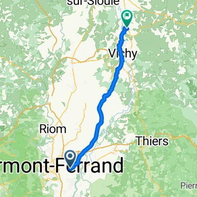
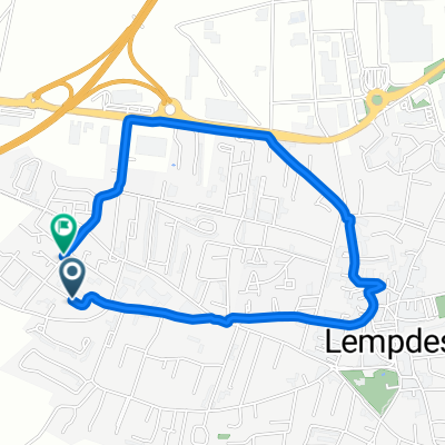
Itinéraire facile en Lempdes
A cycling route starting in Aulnat, Auvergne-Rhône-Alpes, France.
Overview
About this route
- 49 min
- Duration
- 14 km
- Distance
- 198 m
- Ascent
- 200 m
- Descent
- 17.2 km/h
- Avg. speed
- ---
- Max. altitude
Continue with Bikemap
Use, edit, or download this cycling route
You would like to ride Itinéraire facile en Lempdes or customize it for your own trip? Here is what you can do with this Bikemap route:
Free features
- Save this route as favorite or in collections
- Copy & plan your own version of this route
- Sync your route with Garmin or Wahoo
Premium features
Free trial for 3 days, or one-time payment. More about Bikemap Premium.
- Navigate this route on iOS & Android
- Export a GPX / KML file of this route
- Create your custom printout (try it for free)
- Download this route for offline navigation
Discover more Premium features.
Get Bikemap PremiumFrom our community
Other popular routes starting in Aulnat
 AUV D1 90 km
- Distance
- 87.3 km
- Ascent
- 1,302 m
- Descent
- 738 m
- Location
- Aulnat, Auvergne-Rhône-Alpes, France
 Itinéraire facile en Lempdes
- Distance
- 14 km
- Ascent
- 198 m
- Descent
- 200 m
- Location
- Aulnat, Auvergne-Rhône-Alpes, France
 Avenue de l'Europe, Lempdes à Rue Valéry Larbaud, Saint-Germain-des-Fossés
- Distance
- 64.1 km
- Ascent
- 332 m
- Descent
- 392 m
- Location
- Aulnat, Auvergne-Rhône-Alpes, France
 maison
- Distance
- 60.1 km
- Ascent
- 401 m
- Descent
- 343 m
- Location
- Aulnat, Auvergne-Rhône-Alpes, France
 Rondje door Auvergne v1
- Distance
- 439.9 km
- Ascent
- 4,094 m
- Descent
- 4,097 m
- Location
- Aulnat, Auvergne-Rhône-Alpes, France
 De Rue de l'Évent 16, Lempdes à Rue de l'Hermitage 1, Clermont-Ferrand
- Distance
- 7.2 km
- Ascent
- 77 m
- Descent
- 61 m
- Location
- Aulnat, Auvergne-Rhône-Alpes, France
 Rue du Lac Pavin, Lempdes à Rue du Lac Pavin, Lempdes
- Distance
- 3.5 km
- Ascent
- 16 m
- Descent
- 22 m
- Location
- Aulnat, Auvergne-Rhône-Alpes, France
 retour trlb
- Distance
- 5.9 km
- Ascent
- 39 m
- Descent
- 4 m
- Location
- Aulnat, Auvergne-Rhône-Alpes, France
Open it in the app