
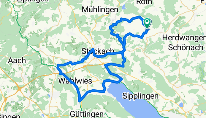
Sonntagsroute
A cycling route starting in Rot, Baden-Wurttemberg, Germany.
Overview
About this route
- -:--
- Duration
- 59.3 km
- Distance
- 547 m
- Ascent
- 554 m
- Descent
- ---
- Avg. speed
- ---
- Max. altitude
Route quality
Waytypes & surfaces along the route
Waytypes
Quiet road
17 km
(29 %)
Path
14.1 km
(24 %)
Surfaces
Paved
44.3 km
(75 %)
Unpaved
8.4 km
(14 %)
Asphalt
43.6 km
(74 %)
Gravel
4.9 km
(8 %)
Continue with Bikemap
Use, edit, or download this cycling route
You would like to ride Sonntagsroute or customize it for your own trip? Here is what you can do with this Bikemap route:
Free features
- Save this route as favorite or in collections
- Copy & plan your own version of this route
- Sync your route with Garmin or Wahoo
Premium features
Free trial for 3 days, or one-time payment. More about Bikemap Premium.
- Navigate this route on iOS & Android
- Export a GPX / KML file of this route
- Create your custom printout (try it for free)
- Download this route for offline navigation
Discover more Premium features.
Get Bikemap PremiumFrom our community
Other popular routes starting in Rot
 Hohenfels Herdwangen Owingen Stockach
- Distance
- 59.9 km
- Ascent
- 463 m
- Descent
- 468 m
- Location
- Rot, Baden-Wurttemberg, Germany
 Liggersdorf Stockach
- Distance
- 33.4 km
- Ascent
- 459 m
- Descent
- 457 m
- Location
- Rot, Baden-Wurttemberg, Germany
 OktoberRoute um Stockach
- Distance
- 53.2 km
- Ascent
- 537 m
- Descent
- 537 m
- Location
- Rot, Baden-Wurttemberg, Germany
 Runde durchn Hegau
- Distance
- 87 km
- Ascent
- 476 m
- Descent
- 485 m
- Location
- Rot, Baden-Wurttemberg, Germany
 Hohenfels Stockach Radolfzell
- Distance
- 66.8 km
- Ascent
- 516 m
- Descent
- 500 m
- Location
- Rot, Baden-Wurttemberg, Germany
 Sonntagsroute
- Distance
- 59.3 km
- Ascent
- 547 m
- Descent
- 554 m
- Location
- Rot, Baden-Wurttemberg, Germany
 Pfullendorf Messkirch Zozznegg
- Distance
- 55.1 km
- Ascent
- 263 m
- Descent
- 267 m
- Location
- Rot, Baden-Wurttemberg, Germany
 TJürgen1 :Liggersdorf-Sauldorf-Schwackenreute-Gallmansweil-Ilgental-Wald
- Distance
- 50.4 km
- Ascent
- 589 m
- Descent
- 588 m
- Location
- Rot, Baden-Wurttemberg, Germany
Open it in the app