

VI TRR Białowieża-Lesko
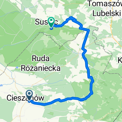
VI TRR Etap 7 - Cieszanów-Przemyśl
A cycling route starting in Cieszanów, Subcarpathian Voivodeship, Poland.
Overview
About this route
- -:--
- Duration
- 99.2 km
- Distance
- 162 m
- Ascent
- 160 m
- Descent
- ---
- Avg. speed
- ---
- Max. altitude

Part of
VI TRR Białowieża-Lesko
9 stages
Route quality
Waytypes & surfaces along the route
Waytypes
Road
40.7 km
(41 %)
Track
14.9 km
(15 %)
Surfaces
Paved
78.3 km
(79 %)
Unpaved
18.8 km
(19 %)
Asphalt
78.3 km
(79 %)
Unpaved (undefined)
10.9 km
(11 %)
Continue with Bikemap
Use, edit, or download this cycling route
You would like to ride VI TRR Etap 7 - Cieszanów-Przemyśl or customize it for your own trip? Here is what you can do with this Bikemap route:
Free features
- Save this route as favorite or in collections
- Copy & plan your own version of this route
- Split it into stages to create a multi-day tour
- Sync your route with Garmin or Wahoo
Premium features
Free trial for 3 days, or one-time payment. More about Bikemap Premium.
- Navigate this route on iOS & Android
- Export a GPX / KML file of this route
- Create your custom printout (try it for free)
- Download this route for offline navigation
Discover more Premium features.
Get Bikemap PremiumFrom our community
Other popular routes starting in Cieszanów
 II dzień jazdy
- Distance
- 106.7 km
- Ascent
- 320 m
- Descent
- 304 m
- Location
- Cieszanów, Subcarpathian Voivodeship, Poland
 Mickiewicza 69, Cieszanów do Mickiewicza 69, Cieszanów
- Distance
- 5.9 km
- Ascent
- 58 m
- Descent
- 56 m
- Location
- Cieszanów, Subcarpathian Voivodeship, Poland
 2015_07_19 Cieszanów - Gorajec - Łówcza - Płazów - Ruda Różaniecka - Narol - Łukawica - Wola Wielka - Dębiny - Huta Złomy - Nowe Brusno - Polanka Horyniecka - P
- Distance
- 92.1 km
- Ascent
- 381 m
- Descent
- 381 m
- Location
- Cieszanów, Subcarpathian Voivodeship, Poland
 Steady ride in Cieszanów
- Distance
- 52 km
- Ascent
- 851 m
- Descent
- 811 m
- Location
- Cieszanów, Subcarpathian Voivodeship, Poland
 Mickiewicza 69, Cieszanów do Mickiewicza 69, Cieszanów
- Distance
- 6 km
- Ascent
- 58 m
- Descent
- 56 m
- Location
- Cieszanów, Subcarpathian Voivodeship, Poland
 Cieszanów
- Distance
- 81.1 km
- Ascent
- 277 m
- Descent
- 270 m
- Location
- Cieszanów, Subcarpathian Voivodeship, Poland
 Cieszanów-Rybnica
- Distance
- 49.3 km
- Ascent
- 206 m
- Descent
- 168 m
- Location
- Cieszanów, Subcarpathian Voivodeship, Poland
 VI TRR Etap 7 - Cieszanów-Przemyśl
- Distance
- 98.9 km
- Ascent
- 362 m
- Descent
- 360 m
- Location
- Cieszanów, Subcarpathian Voivodeship, Poland
Open it in the app