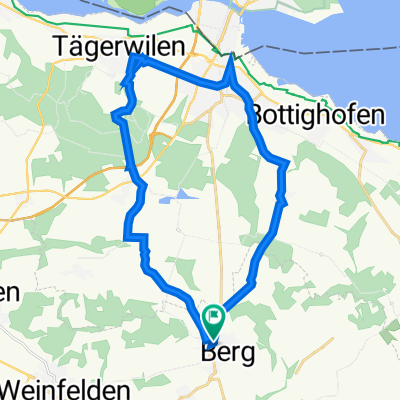
Berg-Riethüsli über Märwil zurück
A cycling route starting in Berg, Thurgau, Switzerland.
Overview
About this route
- 2 h 25 min
- Duration
- 39.3 km
- Distance
- 591 m
- Ascent
- 590 m
- Descent
- 16.3 km/h
- Avg. speed
- ---
- Avg. speed
Route quality
Waytypes & surfaces along the route
Waytypes
Quiet road
15.9 km
(40 %)
Track
13.4 km
(34 %)
Surfaces
Paved
15.4 km
(39 %)
Unpaved
8.8 km
(22 %)
Asphalt
14.9 km
(38 %)
Unpaved (undefined)
7.3 km
(19 %)
Continue with Bikemap
Use, edit, or download this cycling route
You would like to ride Berg-Riethüsli über Märwil zurück or customize it for your own trip? Here is what you can do with this Bikemap route:
Free features
- Save this route as favorite or in collections
- Copy & plan your own version of this route
- Sync your route with Garmin or Wahoo
Premium features
Free trial for 3 days, or one-time payment. More about Bikemap Premium.
- Navigate this route on iOS & Android
- Export a GPX / KML file of this route
- Create your custom printout (try it for free)
- Download this route for offline navigation
Discover more Premium features.
Get Bikemap PremiumFrom our community
Other popular routes starting in Berg
- mit dem crossbike von berg nach villnachern
- Distance
- 99.5 km
- Ascent
- 536 m
- Descent
- 712 m
- Location
- Berg, Thurgau, Switzerland
- Berg-Riethüsli über Märwil zurück
- Distance
- 39.3 km
- Ascent
- 591 m
- Descent
- 590 m
- Location
- Berg, Thurgau, Switzerland
- Seerücken-Route (Siegershausen - Schaffhausen)
- Distance
- 55.4 km
- Ascent
- 483 m
- Descent
- 618 m
- Location
- Berg, Thurgau, Switzerland
- solatour berg raach
- Distance
- 22.8 km
- Ascent
- 197 m
- Descent
- 269 m
- Location
- Berg, Thurgau, Switzerland
- Rundtour Thurweg Bischofszell, Buhwil, Schönholzerswilen
- Distance
- 63.7 km
- Ascent
- 808 m
- Descent
- 809 m
- Location
- Berg, Thurgau, Switzerland
- Berg 1
- Distance
- 29.2 km
- Ascent
- 272 m
- Descent
- 271 m
- Location
- Berg, Thurgau, Switzerland
- Bodenseeruecken
- Distance
- 72.1 km
- Ascent
- 174 m
- Descent
- 319 m
- Location
- Berg, Thurgau, Switzerland
- Ottoberg, Weinfelden nach Dettighoferstrasse 26, Lengwil
- Distance
- 10.2 km
- Ascent
- 42 m
- Descent
- 202 m
- Location
- Berg, Thurgau, Switzerland
Open it in the app