Radltour Bad Tölz - Lenggries
A cycling route starting in Wackersberg, Bavaria, Germany.
Overview
About this route
Radltour Bad Tölz-Lenggries
- -:--
- Duration
- 38.4 km
- Distance
- 270 m
- Ascent
- 268 m
- Descent
- ---
- Avg. speed
- ---
- Avg. speed
Route quality
Waytypes & surfaces along the route
Waytypes
Quiet road
17.2 km
(45 %)
Track
7.4 km
(19 %)
Surfaces
Paved
21.3 km
(55 %)
Unpaved
10 km
(26 %)
Asphalt
18.5 km
(48 %)
Gravel
5.3 km
(14 %)
Continue with Bikemap
Use, edit, or download this cycling route
You would like to ride Radltour Bad Tölz - Lenggries or customize it for your own trip? Here is what you can do with this Bikemap route:
Free features
- Save this route as favorite or in collections
- Copy & plan your own version of this route
- Sync your route with Garmin or Wahoo
Premium features
Free trial for 3 days, or one-time payment. More about Bikemap Premium.
- Navigate this route on iOS & Android
- Export a GPX / KML file of this route
- Create your custom printout (try it for free)
- Download this route for offline navigation
Discover more Premium features.
Get Bikemap PremiumFrom our community
Other popular routes starting in Wackersberg
- Tölz-Eschenlohe-Tölz
- Distance
- 88.1 km
- Ascent
- 503 m
- Descent
- 504 m
- Location
- Wackersberg, Bavaria, Germany
- Mit dem MTB um den Hochtannenkopf
- Distance
- 28.8 km
- Ascent
- 960 m
- Descent
- 961 m
- Location
- Wackersberg, Bavaria, Germany
- Blomberg
- Distance
- 14.9 km
- Ascent
- 736 m
- Descent
- 733 m
- Location
- Wackersberg, Bavaria, Germany
- Blombergrunde
- Distance
- 21.2 km
- Ascent
- 708 m
- Descent
- 707 m
- Location
- Wackersberg, Bavaria, Germany
- Tölz-Osterseen-Tölz
- Distance
- 74.4 km
- Ascent
- 400 m
- Descent
- 400 m
- Location
- Wackersberg, Bavaria, Germany
- Lengries-Walchensee-Mittenwald-Sylvensteinstausee-Lenggries
- Distance
- 110.2 km
- Ascent
- 366 m
- Descent
- 367 m
- Location
- Wackersberg, Bavaria, Germany
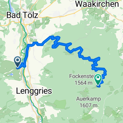
- Blomberghaus - Hochtannenkopf-Runde
- Distance
- 28.4 km
- Ascent
- 923 m
- Descent
- 923 m
- Location
- Wackersberg, Bavaria, Germany
- Blomberg-Runde mit Trails bergab
- Distance
- 12.3 km
- Ascent
- 712 m
- Descent
- 699 m
- Location
- Wackersberg, Bavaria, Germany
Open it in the app