

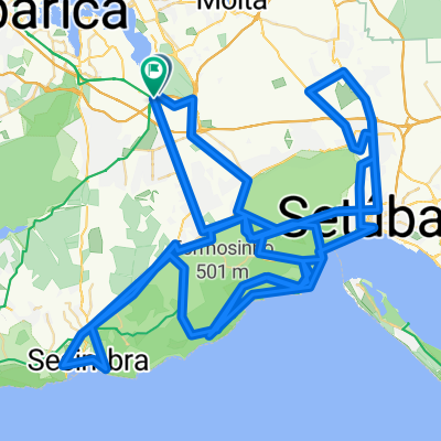
Road 325
A cycling route starting in Santo António da Charneca, Setúbal District, Portugal.
Overview
About this route
- -:--
- Duration
- 328.1 km
- Distance
- 968 m
- Ascent
- 965 m
- Descent
- ---
- Avg. speed
- ---
- Max. altitude

Continue with Bikemap
Use, edit, or download this cycling route
You would like to ride Road 325 or customize it for your own trip? Here is what you can do with this Bikemap route:
Free features
- Save this route as favorite or in collections
- Copy & plan your own version of this route
- Split it into stages to create a multi-day tour
- Sync your route with Garmin or Wahoo
Premium features
Free trial for 3 days, or one-time payment. More about Bikemap Premium.
- Navigate this route on iOS & Android
- Export a GPX / KML file of this route
- Create your custom printout (try it for free)
- Download this route for offline navigation
Discover more Premium features.
Get Bikemap PremiumFrom our community
Other popular routes starting in Santo António da Charneca
 Qta da Lomba - TRAILFORKS - Qta da Lomba
- Distance
- 22.8 km
- Ascent
- 404 m
- Descent
- 406 m
- Location
- Santo António da Charneca, Setúbal District, Portugal
 Volta Capela São Luís e Califórnia
- Distance
- 41.5 km
- Ascent
- 657 m
- Descent
- 657 m
- Location
- Santo António da Charneca, Setúbal District, Portugal
 Volta Capela São Luís e Califor ou não
- Distance
- 41.7 km
- Ascent
- 693 m
- Descent
- 691 m
- Location
- Santo António da Charneca, Setúbal District, Portugal
 Volta Capela São Luís p TODOS
- Distance
- 48.9 km
- Ascent
- 764 m
- Descent
- 764 m
- Location
- Santo António da Charneca, Setúbal District, Portugal
 Road 325
- Distance
- 328.1 km
- Ascent
- 968 m
- Descent
- 965 m
- Location
- Santo António da Charneca, Setúbal District, Portugal
 Vamos subir só um bocadinho 3150m
- Distance
- 160.4 km
- Ascent
- 1,669 m
- Descent
- 1,664 m
- Location
- Santo António da Charneca, Setúbal District, Portugal
 Barreiro - Palmela - Moita - Vale da Amoreira
- Distance
- 45.4 km
- Ascent
- 218 m
- Descent
- 245 m
- Location
- Santo António da Charneca, Setúbal District, Portugal
 G3 - PPP- Saias - Est_Secil - NecVolta -Rei_VaiNú-Califórnia
- Distance
- 55.4 km
- Ascent
- 724 m
- Descent
- 724 m
- Location
- Santo António da Charneca, Setúbal District, Portugal
Open it in the app