

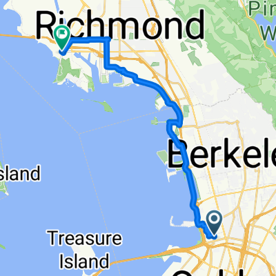
Relaxed route in Berkeley
A cycling route starting in Emeryville, California, United States.
Overview
About this route
- 24 min
- Duration
- 5.7 km
- Distance
- 0 m
- Ascent
- 3 m
- Descent
- 14 km/h
- Avg. speed
- ---
- Max. altitude
Route quality
Waytypes & surfaces along the route
Waytypes
Cycleway
3.9 km
(69 %)
Quiet road
0.5 km
(8 %)
Surfaces
Paved
0.4 km
(7 %)
Paved (undefined)
0.4 km
(7 %)
Undefined
5.3 km
(93 %)
Continue with Bikemap
Use, edit, or download this cycling route
You would like to ride Relaxed route in Berkeley or customize it for your own trip? Here is what you can do with this Bikemap route:
Free features
- Save this route as favorite or in collections
- Copy & plan your own version of this route
- Sync your route with Garmin or Wahoo
Premium features
Free trial for 3 days, or one-time payment. More about Bikemap Premium.
- Navigate this route on iOS & Android
- Export a GPX / KML file of this route
- Create your custom printout (try it for free)
- Download this route for offline navigation
Discover more Premium features.
Get Bikemap PremiumFrom our community
Other popular routes starting in Emeryville
 Skyline trek along Redwood Park, southwest side
- Distance
- 31.8 km
- Ascent
- 521 m
- Descent
- 521 m
- Location
- Emeryville, California, United States
 From Emeryville to Richmond
- Distance
- 20.3 km
- Ascent
- 61 m
- Descent
- 61 m
- Location
- Emeryville, California, United States
 Bay Trail to Shoreline
- Distance
- 11.8 km
- Ascent
- 42 m
- Descent
- 45 m
- Location
- Emeryville, California, United States
 Park-Pinehurst Loop
- Distance
- 47.5 km
- Ascent
- 678 m
- Descent
- 676 m
- Location
- Emeryville, California, United States
 Pt Richmond Loop
- Distance
- 25.1 km
- Ascent
- 0 m
- Descent
- 0 m
- Location
- Emeryville, California, United States
 Christie Avenue 6363, Emeryville to San Francisco
- Distance
- 9 km
- Ascent
- 75 m
- Descent
- 57 m
- Location
- Emeryville, California, United States
 evening mash
- Distance
- 38.3 km
- Ascent
- 3 m
- Descent
- 17 m
- Location
- Emeryville, California, United States
 west oak loop
- Distance
- 25.4 km
- Ascent
- 485 m
- Descent
- 482 m
- Location
- Emeryville, California, United States
Open it in the app