

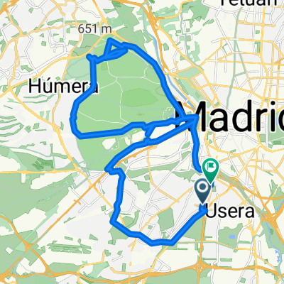
Anillo Verde Ciclista
A cycling route starting in Carabanchel, Madrid, Spain.
Overview
About this route
Anillo Verde Ciclista is a cycling route in Madrid. It features an elevation gain of 858ft over 21.50mi. Notable roads/trails that you'll be traveling on: Anillo Verde Ciclista, Calle Arroyofresno, Puente de San Fernando, Paseo Azul, and Avenida del Ventisquero de la Condesa.
- -:--
- Duration
- 34 km
- Distance
- 243 m
- Ascent
- 241 m
- Descent
- ---
- Avg. speed
- ---
- Max. altitude

Route quality
Waytypes & surfaces along the route
Waytypes
Cycleway
27.9 km
(82 %)
Quiet road
4.8 km
(14 %)
Surfaces
Paved
32 km
(94 %)
Asphalt
18 km
(53 %)
Concrete
13.6 km
(40 %)
Continue with Bikemap
Use, edit, or download this cycling route
You would like to ride Anillo Verde Ciclista or customize it for your own trip? Here is what you can do with this Bikemap route:
Free features
- Save this route as favorite or in collections
- Copy & plan your own version of this route
- Sync your route with Garmin or Wahoo
Premium features
Free trial for 3 days, or one-time payment. More about Bikemap Premium.
- Navigate this route on iOS & Android
- Export a GPX / KML file of this route
- Create your custom printout (try it for free)
- Download this route for offline navigation
Discover more Premium features.
Get Bikemap PremiumFrom our community
Other popular routes starting in Carabanchel
 Running 1
- Distance
- 4.6 km
- Ascent
- 113 m
- Descent
- 47 m
- Location
- Carabanchel, Madrid, Spain
 Oporto-Parque Lineal del Manzanares
- Distance
- 18.9 km
- Ascent
- 97 m
- Descent
- 97 m
- Location
- Carabanchel, Madrid, Spain
 15-05-2011 hasta cerca valpalomero
- Distance
- 39.7 km
- Ascent
- 275 m
- Descent
- 206 m
- Location
- Carabanchel, Madrid, Spain
 Vuelta a la Casa de Campo
- Distance
- 19.7 km
- Ascent
- 149 m
- Descent
- 172 m
- Location
- Carabanchel, Madrid, Spain
 Recorriendo la orilla del Manzanares
- Distance
- 57.9 km
- Ascent
- 238 m
- Descent
- 251 m
- Location
- Carabanchel, Madrid, Spain
 Ruta tranquila en Alcorcón
- Distance
- 17.8 km
- Ascent
- 203 m
- Descent
- 80 m
- Location
- Carabanchel, Madrid, Spain
 Casa de campo bosque A. Suárez
- Distance
- 35.1 km
- Ascent
- 309 m
- Descent
- 313 m
- Location
- Carabanchel, Madrid, Spain
 Carabanchel, Madrid a Calle del Teniente Compaired, Madrid
- Distance
- 16.9 km
- Ascent
- 108 m
- Descent
- 107 m
- Location
- Carabanchel, Madrid, Spain
Open it in the app