

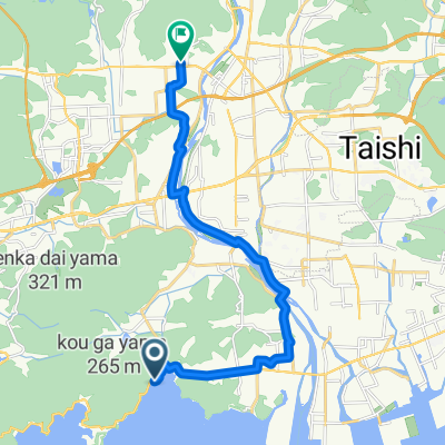
かみごおりダムtoダムコース
A cycling route starting in Aioi, Hyōgo, Japan.
Overview
About this route
- -:--
- Duration
- 48 km
- Distance
- 732 m
- Ascent
- 730 m
- Descent
- ---
- Avg. speed
- ---
- Max. altitude

Route quality
Waytypes & surfaces along the route
Waytypes
Quiet road
12.5 km
(26 %)
Road
4.3 km
(9 %)
Surfaces
Paved
30.2 km
(63 %)
Asphalt
30.2 km
(63 %)
Undefined
17.8 km
(37 %)
Continue with Bikemap
Use, edit, or download this cycling route
You would like to ride かみごおりダムtoダムコース or customize it for your own trip? Here is what you can do with this Bikemap route:
Free features
- Save this route as favorite or in collections
- Copy & plan your own version of this route
- Sync your route with Garmin or Wahoo
Premium features
Free trial for 3 days, or one-time payment. More about Bikemap Premium.
- Navigate this route on iOS & Android
- Export a GPX / KML file of this route
- Create your custom printout (try it for free)
- Download this route for offline navigation
Discover more Premium features.
Get Bikemap PremiumFrom our community
Other popular routes starting in Aioi
 896−23 までたつの市
- Distance
- 16.5 km
- Ascent
- 110 m
- Descent
- 109 m
- Location
- Aioi, Hyōgo, Japan
 国道2号, 相生市へ小松通4丁目, 神戸市
- Distance
- 83.2 km
- Ascent
- 489 m
- Descent
- 522 m
- Location
- Aioi, Hyōgo, Japan
 ぐるっと西播磨
- Distance
- 171.9 km
- Ascent
- 3,145 m
- Descent
- 3,145 m
- Location
- Aioi, Hyōgo, Japan
 896−23 までたつの市
- Distance
- 16.4 km
- Ascent
- 87 m
- Descent
- 99 m
- Location
- Aioi, Hyōgo, Japan
 896−23 まで208−1
- Distance
- 16.6 km
- Ascent
- 77 m
- Descent
- 85 m
- Location
- Aioi, Hyōgo, Japan
 ドッグラン(道の駅 みつ) までたつの市
- Distance
- 16.6 km
- Ascent
- 123 m
- Descent
- 138 m
- Location
- Aioi, Hyōgo, Japan
 ぐるっと西はりま ショートカットルート1
- Distance
- 128.1 km
- Ascent
- 2,021 m
- Descent
- 2,023 m
- Location
- Aioi, Hyōgo, Japan
 165-5, Ibogawachoyamatsuya, Tatsuno to Shinguchokajiya, Tatsuno
- Distance
- 23.6 km
- Ascent
- 227 m
- Descent
- 120 m
- Location
- Aioi, Hyōgo, Japan
Open it in the app