

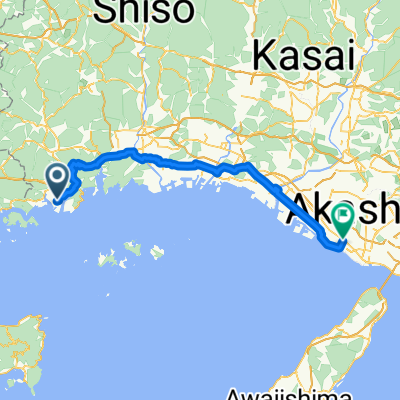
日本遺産・坂越浦を巡るコース
A cycling route starting in Kariya, Hyōgo, Japan.
Overview
About this route
- -:--
- Duration
- 3.9 km
- Distance
- 96 m
- Ascent
- 95 m
- Descent
- ---
- Avg. speed
- ---
- Max. altitude

Route quality
Waytypes & surfaces along the route
Waytypes
Quiet road
1.3 km
(33 %)
Road
0.7 km
(17 %)
Undefined
2 km
(50 %)
Surfaces
Paved
2.4 km
(62 %)
Asphalt
2.4 km
(62 %)
Undefined
1.5 km
(38 %)
Continue with Bikemap
Use, edit, or download this cycling route
You would like to ride 日本遺産・坂越浦を巡るコース or customize it for your own trip? Here is what you can do with this Bikemap route:
Free features
- Save this route as favorite or in collections
- Copy & plan your own version of this route
- Sync your route with Garmin or Wahoo
Premium features
Free trial for 3 days, or one-time payment. More about Bikemap Premium.
- Navigate this route on iOS & Android
- Export a GPX / KML file of this route
- Create your custom printout (try it for free)
- Download this route for offline navigation
Discover more Premium features.
Get Bikemap PremiumFrom our community
Other popular routes starting in Kariya
 Kariya - Himeji
- Distance
- 76 km
- Ascent
- 793 m
- Descent
- 773 m
- Location
- Kariya, Hyōgo, Japan
 Day 32: Himeji
- Distance
- 46.5 km
- Ascent
- 196 m
- Descent
- 202 m
- Location
- Kariya, Hyōgo, Japan
 Day - 23 Maruyama Kemmin to Hongo ikoi (29/10/2019)
- Distance
- 134 km
- Ascent
- 0 m
- Descent
- 0 m
- Location
- Kariya, Hyōgo, Japan
 頭島から湯郷
- Distance
- 58.7 km
- Ascent
- 990 m
- Descent
- 932 m
- Location
- Kariya, Hyōgo, Japan
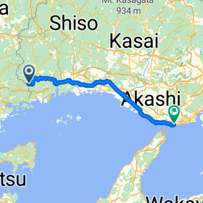 Kariya - Akashi
- Distance
- 96.7 km
- Ascent
- 978 m
- Descent
- 1,123 m
- Location
- Kariya, Hyōgo, Japan
 片鉄ロマン街道ルート _01 (Hinase start)
- Distance
- 36.5 km
- Ascent
- 178 m
- Descent
- 130 m
- Location
- Kariya, Hyōgo, Japan
 katatetsu roman cycle route
- Distance
- 32.9 km
- Ascent
- 197 m
- Descent
- 165 m
- Location
- Kariya, Hyōgo, Japan
 Day- 23 (alternative route) maruyama to kojima and train to utazu (29/10/2019)
- Distance
- 86.1 km
- Ascent
- 294 m
- Descent
- 292 m
- Location
- Kariya, Hyōgo, Japan
Open it in the app