

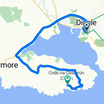
Dingle a Killarney
A cycling route starting in Dingle, Munster, Ireland.
Overview
About this route
- -:--
- Duration
- 66.3 km
- Distance
- 417 m
- Ascent
- 388 m
- Descent
- ---
- Avg. speed
- ---
- Max. altitude

Route quality
Waytypes & surfaces along the route
Waytypes
Quiet road
15.2 km
(23 %)
Road
1.3 km
(2 %)
Surfaces
Paved
26.5 km
(40 %)
Asphalt
26.5 km
(40 %)
Undefined
39.8 km
(60 %)
Continue with Bikemap
Use, edit, or download this cycling route
You would like to ride Dingle a Killarney or customize it for your own trip? Here is what you can do with this Bikemap route:
Free features
- Save this route as favorite or in collections
- Copy & plan your own version of this route
- Sync your route with Garmin or Wahoo
Premium features
Free trial for 3 days, or one-time payment. More about Bikemap Premium.
- Navigate this route on iOS & Android
- Export a GPX / KML file of this route
- Create your custom printout (try it for free)
- Download this route for offline navigation
Discover more Premium features.
Get Bikemap PremiumFrom our community
Other popular routes starting in Dingle
 Dingle a Killarney
- Distance
- 66.3 km
- Ascent
- 417 m
- Descent
- 388 m
- Location
- Dingle, Munster, Ireland
 Slea Head
- Distance
- 39.3 km
- Ascent
- 286 m
- Descent
- 286 m
- Location
- Dingle, Munster, Ireland
 Dingle peninsula
- Distance
- 9.8 km
- Ascent
- 302 m
- Descent
- 149 m
- Location
- Dingle, Munster, Ireland
 Dingle - Dingle
- Distance
- 40.1 km
- Ascent
- 423 m
- Descent
- 423 m
- Location
- Dingle, Munster, Ireland
 012 Tour of the Dingle Peninsula
- Distance
- 55.8 km
- Ascent
- 324 m
- Descent
- 324 m
- Location
- Dingle, Munster, Ireland
 Tag 31: Dingle - Mündung Shannon
- Distance
- 92.4 km
- Ascent
- 559 m
- Descent
- 858 m
- Location
- Dingle, Munster, Ireland
 Dingle
- Distance
- 56.1 km
- Ascent
- 540 m
- Descent
- 540 m
- Location
- Dingle, Munster, Ireland
 R559, Ballydavid à Cosán na Naomh, Ballydavid
- Distance
- 48.1 km
- Ascent
- 867 m
- Descent
- 797 m
- Location
- Dingle, Munster, Ireland
Open it in the app