
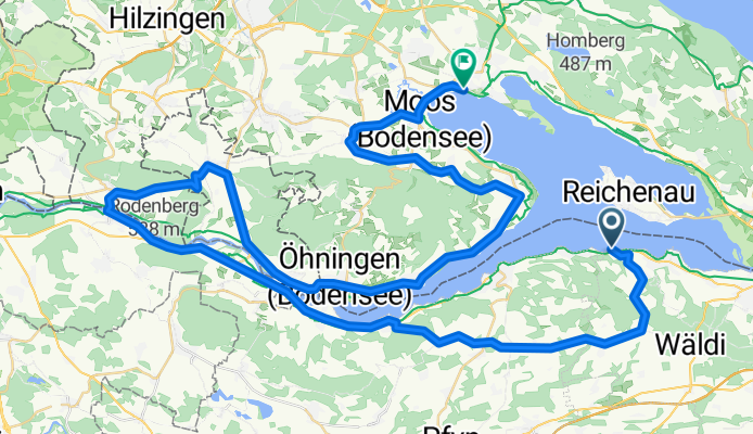
MANNENBACH / CH via STEIN a. RHEIN / CH und retour n. RADOLFZELL
A cycling route starting in Ermatingen, Thurgau, Switzerland.
Overview
About this route
The morning 'transfer' from Radolfzell to Mannenbach takes place at 09:25 by Lake Constance ferry and lasts about 35 minutes. - Upon arrival, there is a fairly 'steep' climb at Mannenbach (via Arenenberg) with 230 meters of elevation over less than 4 km, ... but afterwards, you are rewarded on the 'high plateau' of the Swiss ridge with fantastic scenery and very low traffic at the same time! - It's worth it!!! - The further 'return ride' from Eschenz to Radolfzell train station / ferry dock is also very varied! - Have fun!!!
- -:--
- Duration
- 73.6 km
- Distance
- 564 m
- Ascent
- 564 m
- Descent
- ---
- Avg. speed
- ---
- Max. altitude
Route quality
Waytypes & surfaces along the route
Waytypes
Road
16.9 km
(23 %)
Quiet road
11 km
(15 %)
Surfaces
Paved
59.6 km
(81 %)
Unpaved
4.4 km
(6 %)
Asphalt
58.9 km
(80 %)
Pebblestone
2.9 km
(4 %)
Continue with Bikemap
Use, edit, or download this cycling route
You would like to ride MANNENBACH / CH via STEIN a. RHEIN / CH und retour n. RADOLFZELL or customize it for your own trip? Here is what you can do with this Bikemap route:
Free features
- Save this route as favorite or in collections
- Copy & plan your own version of this route
- Sync your route with Garmin or Wahoo
Premium features
Free trial for 3 days, or one-time payment. More about Bikemap Premium.
- Navigate this route on iOS & Android
- Export a GPX / KML file of this route
- Create your custom printout (try it for free)
- Download this route for offline navigation
Discover more Premium features.
Get Bikemap PremiumFrom our community
Other popular routes starting in Ermatingen
 13 112, Ermatingen to Blumenweg 1, Ermatingen
- Distance
- 36.1 km
- Ascent
- 374 m
- Descent
- 377 m
- Location
- Ermatingen, Thurgau, Switzerland
 Seerücken West
- Distance
- 58 km
- Ascent
- 616 m
- Descent
- 496 m
- Location
- Ermatingen, Thurgau, Switzerland
 Heimgartenstrasse 1, Ermatingen to Hornstrasse 3, Ermatingen
- Distance
- 45.5 km
- Ascent
- 311 m
- Descent
- 316 m
- Location
- Ermatingen, Thurgau, Switzerland
 Triboltingen - Paris
- Distance
- 1,025.7 km
- Ascent
- 403 m
- Descent
- 746 m
- Location
- Ermatingen, Thurgau, Switzerland
 Um den Untersee
- Distance
- 70.5 km
- Ascent
- 242 m
- Descent
- 242 m
- Location
- Ermatingen, Thurgau, Switzerland
 MANNENBACH / CH via STEIN a. RHEIN / CH und retour n. RADOLFZELL
- Distance
- 73.6 km
- Ascent
- 564 m
- Descent
- 564 m
- Location
- Ermatingen, Thurgau, Switzerland
 Bis Konstanz
- Distance
- 12.4 km
- Ascent
- 40 m
- Descent
- 39 m
- Location
- Ermatingen, Thurgau, Switzerland
 Hofackerstrasse, Ermatingen nach Hofackerstrasse 25E, Ermatingen
- Distance
- 19.2 km
- Ascent
- 262 m
- Descent
- 263 m
- Location
- Ermatingen, Thurgau, Switzerland
Open it in the app