

Sie to MMz 4.0
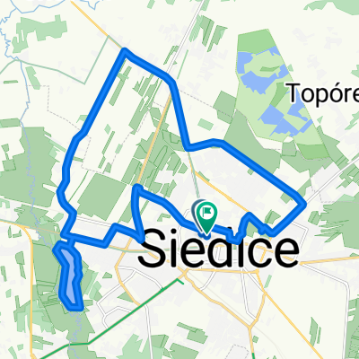
A cycling route starting in Siedlce, Masovian Voivodeship, Poland.
Overview
About this route
Many historic sites along the route, beautiful meadows of the Liwiec Sanctuary. Mixed roads, asphalt and gravel roads, forest and field paths. Before Grodzisk, you have to cross the Struga river. The route is for strong tourists, MTB, cross. For the adventurous, there is a big shortcut from Janówek to Zimnowody through the forest, peat road, traces of heavy equipment (tractors). Return from Mińsk Maz. trains every 1 hour, 0.5 hours.
- -:--
- Duration
- 94.9 km
- Distance
- 179 m
- Ascent
- 170 m
- Descent
- ---
- Avg. speed
- ---
- Max. altitude

Route quality
Waytypes & surfaces along the route
Waytypes
Road
45.6 km
(48 %)
Quiet road
25.6 km
(27 %)
Surfaces
Paved
53.2 km
(56 %)
Unpaved
8.5 km
(9 %)
Asphalt
53.2 km
(56 %)
Sand
5.7 km
(6 %)
Continue with Bikemap
Use, edit, or download this cycling route
You would like to ride Sie to MMz 4.0 or customize it for your own trip? Here is what you can do with this Bikemap route:
Free features
- Save this route as favorite or in collections
- Copy & plan your own version of this route
- Split it into stages to create a multi-day tour
- Sync your route with Garmin or Wahoo
Premium features
Free trial for 3 days, or one-time payment. More about Bikemap Premium.
- Navigate this route on iOS & Android
- Export a GPX / KML file of this route
- Create your custom printout (try it for free)
- Download this route for offline navigation
Discover more Premium features.
Get Bikemap PremiumFrom our community
Other popular routes starting in Siedlce
 Siedlce Piaski/Strzała/ Iganie/Siedlce
- Distance
- 12.5 km
- Ascent
- 21 m
- Descent
- 22 m
- Location
- Siedlce, Masovian Voivodeship, Poland
 Siedlce-Mielnik
- Distance
- 98.5 km
- Ascent
- 230 m
- Descent
- 258 m
- Location
- Siedlce, Masovian Voivodeship, Poland
 Tour de Siedlce
- Distance
- 102.6 km
- Ascent
- 131 m
- Descent
- 133 m
- Location
- Siedlce, Masovian Voivodeship, Poland
 pętla Siedlce/Krześlinek
- Distance
- 30.6 km
- Ascent
- 61 m
- Descent
- 61 m
- Location
- Siedlce, Masovian Voivodeship, Poland
 2020-06-11 18:03:29
- Distance
- 3.6 km
- Ascent
- 8 m
- Descent
- 39 m
- Location
- Siedlce, Masovian Voivodeship, Poland
 Kropka na Podlasiu
- Distance
- 148.1 km
- Ascent
- 206 m
- Descent
- 229 m
- Location
- Siedlce, Masovian Voivodeship, Poland
 Pierwsza udokumentowana
- Distance
- 20.6 km
- Ascent
- 38 m
- Descent
- 37 m
- Location
- Siedlce, Masovian Voivodeship, Poland
 Siedlce-Międzyrzec Podl.-Łosice-Mordy-Siedlce
- Distance
- 96.4 km
- Ascent
- 107 m
- Descent
- 106 m
- Location
- Siedlce, Masovian Voivodeship, Poland
Open it in the app