

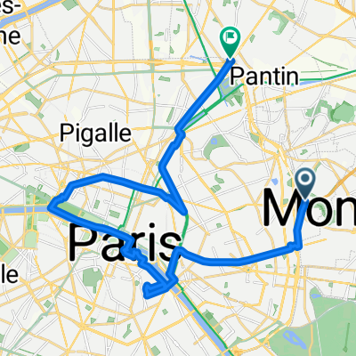
Canal - Senlis - Chantilly
A cycling route starting in Bagnolet, Île-de-France Region, France.
Overview
About this route
ruelles médiévales de Senlis - château de Chantilly 76,5km -
- -:--
- Duration
- 126.6 km
- Distance
- 425 m
- Ascent
- 389 m
- Descent
- ---
- Avg. speed
- ---
- Max. altitude

Route quality
Waytypes & surfaces along the route
Waytypes
Quiet road
41.8 km
(33 %)
Road
26.6 km
(21 %)
Surfaces
Paved
68.3 km
(54 %)
Unpaved
8.9 km
(7 %)
Asphalt
62 km
(49 %)
Concrete
5.1 km
(4 %)
Route highlights
Points of interest along the route
Point of interest after 46.5 km
Gare de chantilly - Gouvieux
Point of interest after 57.4 km
Point of interest after 58.8 km
ruelles médiévales
Continue with Bikemap
Use, edit, or download this cycling route
You would like to ride Canal - Senlis - Chantilly or customize it for your own trip? Here is what you can do with this Bikemap route:
Free features
- Save this route as favorite or in collections
- Copy & plan your own version of this route
- Split it into stages to create a multi-day tour
- Sync your route with Garmin or Wahoo
Premium features
Free trial for 3 days, or one-time payment. More about Bikemap Premium.
- Navigate this route on iOS & Android
- Export a GPX / KML file of this route
- Create your custom printout (try it for free)
- Download this route for offline navigation
Discover more Premium features.
Get Bikemap PremiumFrom our community
Other popular routes starting in Bagnolet
 Etapa 023C (París - Bresles)
- Distance
- 124.2 km
- Ascent
- 785 m
- Descent
- 809 m
- Location
- Bagnolet, Île-de-France Region, France
 Les coteaux et la véloscénie
- Distance
- 39 km
- Ascent
- 246 m
- Descent
- 247 m
- Location
- Bagnolet, Île-de-France Region, France
 Paris Tag 1
- Distance
- 22.4 km
- Ascent
- 94 m
- Descent
- 123 m
- Location
- Bagnolet, Île-de-France Region, France
 Grande boucle VTT à faire
- Distance
- 73.3 km
- Ascent
- 193 m
- Descent
- 193 m
- Location
- Bagnolet, Île-de-France Region, France
 Marnes et Ourq
- Distance
- 103.3 km
- Ascent
- 202 m
- Descent
- 202 m
- Location
- Bagnolet, Île-de-France Region, France
 2011-01 2work
- Distance
- 9.4 km
- Ascent
- 67 m
- Descent
- 97 m
- Location
- Bagnolet, Île-de-France Region, France
 aubervilliers a viarmes
- Distance
- 36.2 km
- Ascent
- 221 m
- Descent
- 261 m
- Location
- Bagnolet, Île-de-France Region, France
 Paris - Tours
- Distance
- 241.3 km
- Ascent
- 319 m
- Descent
- 334 m
- Location
- Bagnolet, Île-de-France Region, France
Open it in the app