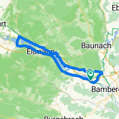
2020-05-27 V2
A cycling route starting in Bischberg, Bavaria, Germany.
Overview
About this route
- -:--
- Duration
- 101.1 km
- Distance
- 698 m
- Ascent
- 697 m
- Descent
- ---
- Avg. speed
- ---
- Avg. speed
Route quality
Waytypes & surfaces along the route
Waytypes
Road
25.6 km
(25 %)
Path
21.1 km
(21 %)
Surfaces
Paved
75.9 km
(75 %)
Unpaved
0.3 km
(<1 %)
Asphalt
73.3 km
(73 %)
Paved (undefined)
1.5 km
(1 %)
Continue with Bikemap
Use, edit, or download this cycling route
You would like to ride 2020-05-27 V2 or customize it for your own trip? Here is what you can do with this Bikemap route:
Free features
- Save this route as favorite or in collections
- Copy & plan your own version of this route
- Sync your route with Garmin or Wahoo
Premium features
Free trial for 3 days, or one-time payment. More about Bikemap Premium.
- Navigate this route on iOS & Android
- Export a GPX / KML file of this route
- Create your custom printout (try it for free)
- Download this route for offline navigation
Discover more Premium features.
Get Bikemap PremiumFrom our community
Other popular routes starting in Bischberg
- von Bamberg in den Steigerwald
- Distance
- 40.9 km
- Ascent
- 533 m
- Descent
- 512 m
- Location
- Bischberg, Bavaria, Germany
- Mainradweg
- Distance
- 248 km
- Ascent
- 128 m
- Descent
- 224 m
- Location
- Bischberg, Bavaria, Germany
- Nuernberg_Bamberg
- Distance
- 76.4 km
- Ascent
- 150 m
- Descent
- 72 m
- Location
- Bischberg, Bavaria, Germany
- Brauereirunde in die Fränkische Schweiz
- Distance
- 65.5 km
- Ascent
- 614 m
- Descent
- 618 m
- Location
- Bischberg, Bavaria, Germany
- vier Täler von Bamberg
- Distance
- 51.7 km
- Ascent
- 337 m
- Descent
- 326 m
- Location
- Bischberg, Bavaria, Germany
- feuersteinroute
- Distance
- 81.5 km
- Ascent
- 1,119 m
- Descent
- 1,110 m
- Location
- Bischberg, Bavaria, Germany
- Von Bamberg zum Reundorfer Keller und Bauernmuseum in Frensdorf
- Distance
- 40.5 km
- Ascent
- 241 m
- Descent
- 217 m
- Location
- Bischberg, Bavaria, Germany
- 06_Bamberg-Nürnberg
- Distance
- 79.4 km
- Ascent
- 128 m
- Descent
- 27 m
- Location
- Bischberg, Bavaria, Germany
Open it in the app