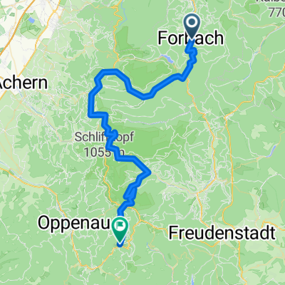
Zum Hohlohturm auf 990m
A cycling route starting in Forbach, Baden-Wurttemberg, Germany.
Overview
About this route
Last night, we camped above Forbach. At midday, we tackled the 'Over the Old Wine Road' route. This tour was a suggestion from the Mountainbike-Arena Murgtal-Enztal. It climbed up to the Hohloh Tower with a fantastic view as a reward. Along the way, we regularly came across fountains to refill our water supplies. After the descent, we did another loop in Gausbach because of all the fountains there. #noebike
- -:--
- Duration
- 27.6 km
- Distance
- 854 m
- Ascent
- 857 m
- Descent
- ---
- Avg. speed
- ---
- Max. altitude
Route photos
Route quality
Waytypes & surfaces along the route
Waytypes
Track
22.9 km
(83 %)
Quiet road
3.3 km
(12 %)
Surfaces
Paved
8 km
(29 %)
Unpaved
18.5 km
(67 %)
Gravel
16.3 km
(59 %)
Asphalt
8 km
(29 %)
Continue with Bikemap
Use, edit, or download this cycling route
You would like to ride Zum Hohlohturm auf 990m or customize it for your own trip? Here is what you can do with this Bikemap route:
Free features
- Save this route as favorite or in collections
- Copy & plan your own version of this route
- Sync your route with Garmin or Wahoo
Premium features
Free trial for 3 days, or one-time payment. More about Bikemap Premium.
- Navigate this route on iOS & Android
- Export a GPX / KML file of this route
- Create your custom printout (try it for free)
- Download this route for offline navigation
Discover more Premium features.
Get Bikemap PremiumFrom our community
Other popular routes starting in Forbach
- Westweg_2.Etappe
- Distance
- 62.6 km
- Ascent
- 1,546 m
- Descent
- 1,176 m
- Location
- Forbach, Baden-Wurttemberg, Germany
- Winterhardtstraße, Forbach nach Murgtalstraße, Forbach
- Distance
- 24.3 km
- Ascent
- 1,047 m
- Descent
- 1,132 m
- Location
- Forbach, Baden-Wurttemberg, Germany
- Baden-Baden nach Herrenwies 35, Forbach
- Distance
- 11 km
- Ascent
- 318 m
- Descent
- 195 m
- Location
- Forbach, Baden-Wurttemberg, Germany
- Forbach - Giersteine - Alter Sportplatz - Antoniusbrunnen - Holzbrücke - Forbach
- Distance
- 7 km
- Ascent
- 284 m
- Descent
- 286 m
- Location
- Forbach, Baden-Wurttemberg, Germany
- Schwarzwald Umrundung
- Distance
- 448.6 km
- Ascent
- 2,986 m
- Descent
- 2,986 m
- Location
- Forbach, Baden-Wurttemberg, Germany
- Schwarzwald 02: Forbach - Bad Peterstal
- Distance
- 71.4 km
- Ascent
- 1,272 m
- Descent
- 1,171 m
- Location
- Forbach, Baden-Wurttemberg, Germany
- Forbach - Saagenweg - Winterhart - Wasserfall - Toter Mann - Forbach
- Distance
- 26.4 km
- Ascent
- 889 m
- Descent
- 907 m
- Location
- Forbach, Baden-Wurttemberg, Germany
- M Westweg Schwarzenachtalsperre Hausach 70km 1770
- Distance
- 69.7 km
- Ascent
- 1,348 m
- Descent
- 1,616 m
- Location
- Forbach, Baden-Wurttemberg, Germany
Open it in the app