

Niguelas
A cycling route starting in Nigüelas, Andalusia, Spain.
Overview
About this route
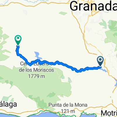
To get to the start take the Tallo road out of Lanjaron, turn Laft at the Tallo junction/metreological station afetr 3km on a big bed and junction park. The ride starts here , long ascents but not to difficult following waymarkers for the Sulayr walking route.. Spaectacular viwes of west ridge of cerro de caballo . Stop at mirador rinconages de Niguelas. Nice long descants back to the car. If you are feeling super fit you can park the car at the tello junction or any point on the drive in.
- -:--
- Duration
- 7.5 km
- Distance
- 562 m
- Ascent
- 385 m
- Descent
- ---
- Avg. speed
- ---
- Max. altitude
Route quality
Waytypes & surfaces along the route
Waytypes
Track
7.5 km
(100 %)
Surfaces
Unpaved
6.8 km
(90 %)
Gravel
6.8 km
(90 %)
Undefined
0.8 km
(10 %)
Continue with Bikemap
Use, edit, or download this cycling route
You would like to ride Niguelas or customize it for your own trip? Here is what you can do with this Bikemap route:
Free features
- Save this route as favorite or in collections
- Copy & plan your own version of this route
- Sync your route with Garmin or Wahoo
Premium features
Free trial for 3 days, or one-time payment. More about Bikemap Premium.
- Navigate this route on iOS & Android
- Export a GPX / KML file of this route
- Create your custom printout (try it for free)
- Download this route for offline navigation
Discover more Premium features.
Get Bikemap PremiumFrom our community
Other popular routes starting in Nigüelas
 Niguelas
- Distance
- 7.5 km
- Ascent
- 562 m
- Descent
- 385 m
- Location
- Nigüelas, Andalusia, Spain
 Nigüelas - Loma de los tres mojones
- Distance
- 48.4 km
- Ascent
- 1,587 m
- Descent
- 1,584 m
- Location
- Nigüelas, Andalusia, Spain
 Day06Trail
- Distance
- 37.4 km
- Ascent
- 752 m
- Descent
- 984 m
- Location
- Nigüelas, Andalusia, Spain
 Granada Baza
- Distance
- 479.3 km
- Ascent
- 5,596 m
- Descent
- 5,670 m
- Location
- Nigüelas, Andalusia, Spain
 Nigüelas - río Torrente
- Distance
- 30.9 km
- Ascent
- 1,276 m
- Descent
- 1,273 m
- Location
- Nigüelas, Andalusia, Spain
 121226 melegis-alhamadegranada
- Distance
- 59 km
- Ascent
- 1,112 m
- Descent
- 887 m
- Location
- Nigüelas, Andalusia, Spain
 INTEGRAL SIERRA NEVADA
- Distance
- 67.6 km
- Ascent
- 3,121 m
- Descent
- 4,105 m
- Location
- Nigüelas, Andalusia, Spain
 TA_11 Nigüelas - Pampaneira
- Distance
- 42.3 km
- Ascent
- 1,365 m
- Descent
- 1,236 m
- Location
- Nigüelas, Andalusia, Spain
Open it in the app