

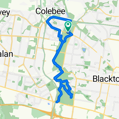
ku ring gai
A cycling route starting in Glendenning, New South Wales, Australia.
Overview
About this route
- -:--
- Duration
- 90.8 km
- Distance
- 627 m
- Ascent
- 624 m
- Descent
- ---
- Avg. speed
- ---
- Max. altitude

Route quality
Waytypes & surfaces along the route
Waytypes
Cycleway
19.1 km
(21 %)
Quiet road
14.5 km
(16 %)
Surfaces
Paved
87.1 km
(96 %)
Asphalt
47.2 km
(52 %)
Paved (undefined)
33.6 km
(37 %)
Continue with Bikemap
Use, edit, or download this cycling route
You would like to ride ku ring gai or customize it for your own trip? Here is what you can do with this Bikemap route:
Free features
- Save this route as favorite or in collections
- Copy & plan your own version of this route
- Split it into stages to create a multi-day tour
- Sync your route with Garmin or Wahoo
Premium features
Free trial for 3 days, or one-time payment. More about Bikemap Premium.
- Navigate this route on iOS & Android
- Export a GPX / KML file of this route
- Create your custom printout (try it for free)
- Download this route for offline navigation
Discover more Premium features.
Get Bikemap PremiumFrom our community
Other popular routes starting in Glendenning
 daddy and Chloe
- Distance
- 26.3 km
- Ascent
- 244 m
- Descent
- 237 m
- Location
- Glendenning, New South Wales, Australia
 ku ring gai
- Distance
- 90.8 km
- Ascent
- 627 m
- Descent
- 624 m
- Location
- Glendenning, New South Wales, Australia
 44 Chilton Avenue, Oakhurst to 44 Chilton Avenue, Oakhurst
- Distance
- 23 km
- Ascent
- 115 m
- Descent
- 160 m
- Location
- Glendenning, New South Wales, Australia
 31 Florence Street, Oakhurst to 44 Chilton Avenue, Oakhurst
- Distance
- 23.7 km
- Ascent
- 182 m
- Descent
- 209 m
- Location
- Glendenning, New South Wales, Australia
 blaxs
blaxs- Distance
- 149.3 km
- Ascent
- 1,836 m
- Descent
- 1,840 m
- Location
- Glendenning, New South Wales, Australia
 Sunday Morning
- Distance
- 26.2 km
- Ascent
- 294 m
- Descent
- 296 m
- Location
- Glendenning, New South Wales, Australia
 Richmond Road 489, Quakers Hill to Richmond Road 489, Quakers Hill
- Distance
- 22.5 km
- Ascent
- 34 m
- Descent
- 35 m
- Location
- Glendenning, New South Wales, Australia
 Richmond Road 489, Quakers Hill to Richmond Road 489, Quakers Hill
- Distance
- 23.8 km
- Ascent
- 189 m
- Descent
- 170 m
- Location
- Glendenning, New South Wales, Australia
Open it in the app