

Race to Thieval UK Side
A cycling route starting in Sturry, England, United Kingdom.
Overview
About this route
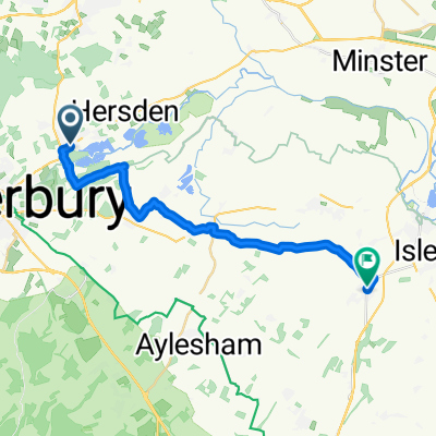
Canterbury Park and Ride to Dover Docks Entrance Via Low density roads and cycle tracks Natinal Route 1.
- -:--
- Duration
- 48.1 km
- Distance
- 209 m
- Ascent
- 204 m
- Descent
- ---
- Avg. speed
- ---
- Max. altitude
Route quality
Waytypes & surfaces along the route
Waytypes
Quiet road
25 km
(52 %)
Road
11 km
(23 %)
Surfaces
Paved
40.3 km
(84 %)
Unpaved
2.5 km
(5 %)
Asphalt
40 km
(83 %)
Ground
2.3 km
(5 %)
Continue with Bikemap
Use, edit, or download this cycling route
You would like to ride Race to Thieval UK Side or customize it for your own trip? Here is what you can do with this Bikemap route:
Free features
- Save this route as favorite or in collections
- Copy & plan your own version of this route
- Sync your route with Garmin or Wahoo
Premium features
Free trial for 3 days, or one-time payment. More about Bikemap Premium.
- Navigate this route on iOS & Android
- Export a GPX / KML file of this route
- Create your custom printout (try it for free)
- Download this route for offline navigation
Discover more Premium features.
Get Bikemap PremiumFrom our community
Other popular routes starting in Sturry
 76 Island Road, Canterbury to Vine Cottage, Sandwich Road, Sandwich
- Distance
- 19.7 km
- Ascent
- 3 m
- Descent
- 15 m
- Location
- Sturry, England, United Kingdom
 8A Fordwich Road, Canterbury to 36 Burgate, Canterbury
- Distance
- 4.5 km
- Ascent
- 3 m
- Descent
- 0 m
- Location
- Sturry, England, United Kingdom
 The Paddle House, Grove Ferry, Canterbury to The Paddle House, Grove Ferry, Canterbury
- Distance
- 16.6 km
- Ascent
- 10 m
- Descent
- 10 m
- Location
- Sturry, England, United Kingdom
 Wickhambreaux to Unnamed Road
- Distance
- 21.2 km
- Ascent
- 17 m
- Descent
- 16 m
- Location
- Sturry, England, United Kingdom
 76 Shalloak Road, Canterbury to 78 Shalloak Road, Canterbury
- Distance
- 30.5 km
- Ascent
- 79 m
- Descent
- 132 m
- Location
- Sturry, England, United Kingdom
 Longmarket 6 to Vauxhall Road 4
- Distance
- 11.9 km
- Ascent
- 79 m
- Descent
- 125 m
- Location
- Sturry, England, United Kingdom
 78 Shalloak Road, Canterbury to 78 Shalloak Road, Canterbury
- Distance
- 36 km
- Ascent
- 78 m
- Descent
- 127 m
- Location
- Sturry, England, United Kingdom
 Race to Thieval UK Side
- Distance
- 48.1 km
- Ascent
- 209 m
- Descent
- 204 m
- Location
- Sturry, England, United Kingdom
Open it in the app