

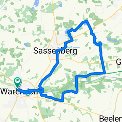
WAF - Vinnenberg - Schloss Harkotten - Sassenberg - WAF
A cycling route starting in Warendorf, North Rhine-Westphalia, Germany.
Overview
About this route
A route through the beautiful Münsterland, passing mills, monasteries, castles, and the most famous ice cream parlor in the entire area. Start and finish in historic old Warendorf.
- -:--
- Duration
- 51 km
- Distance
- 83 m
- Ascent
- 82 m
- Descent
- ---
- Avg. speed
- ---
- Max. altitude

Route quality
Waytypes & surfaces along the route
Waytypes
Quiet road
34.2 km
(67 %)
Path
5.6 km
(11 %)
Surfaces
Paved
34.2 km
(67 %)
Unpaved
5.6 km
(11 %)
Asphalt
31.6 km
(62 %)
Gravel
4.6 km
(9 %)
Route highlights
Points of interest along the route
Point of interest after 16.8 km
Gasthaus zum kühlen Grunde
Point of interest after 25.8 km
Schlosscafe Harkotten
Point of interest after 43.1 km
Eiscafé
Point of interest after 49.9 km
Freibadparkplatz WAF - hinter der Tankstelle
Continue with Bikemap
Use, edit, or download this cycling route
You would like to ride WAF - Vinnenberg - Schloss Harkotten - Sassenberg - WAF or customize it for your own trip? Here is what you can do with this Bikemap route:
Free features
- Save this route as favorite or in collections
- Copy & plan your own version of this route
- Sync your route with Garmin or Wahoo
Premium features
Free trial for 3 days, or one-time payment. More about Bikemap Premium.
- Navigate this route on iOS & Android
- Export a GPX / KML file of this route
- Create your custom printout (try it for free)
- Download this route for offline navigation
Discover more Premium features.
Get Bikemap PremiumFrom our community
Other popular routes starting in Warendorf
 Freckenhorst-Müssingen-Telgte-Everswinkel-Cafe Eichenhof-Freckenhorst
- Distance
- 45.5 km
- Ascent
- 142 m
- Descent
- 141 m
- Location
- Warendorf, North Rhine-Westphalia, Germany
 Warendorf - Sassenberg - Rundtour
- Distance
- 30.6 km
- Ascent
- 81 m
- Descent
- 78 m
- Location
- Warendorf, North Rhine-Westphalia, Germany
 Rundtour Warendorf
- Distance
- 28.4 km
- Ascent
- 54 m
- Descent
- 54 m
- Location
- Warendorf, North Rhine-Westphalia, Germany
 Emsradweg
- Distance
- 283.5 km
- Ascent
- 60 m
- Descent
- 108 m
- Location
- Warendorf, North Rhine-Westphalia, Germany
 Von Warendorf nach Schloss Harkotten
- Distance
- 33.5 km
- Ascent
- 69 m
- Descent
- 70 m
- Location
- Warendorf, North Rhine-Westphalia, Germany
 1.Mai Tour 2009
- Distance
- 37.8 km
- Ascent
- 56 m
- Descent
- 55 m
- Location
- Warendorf, North Rhine-Westphalia, Germany
 von Warendorf nach Brilon
- Distance
- 122.8 km
- Ascent
- 759 m
- Descent
- 235 m
- Location
- Warendorf, North Rhine-Westphalia, Germany
 Grenzweg-1
- Distance
- 69 km
- Ascent
- 93 m
- Descent
- 92 m
- Location
- Warendorf, North Rhine-Westphalia, Germany
Open it in the app