

Fahren & Fressen: Yogihaus
A cycling route starting in Alt-Treptow, State of Berlin, Germany.
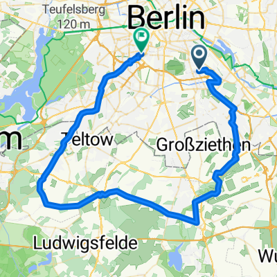
Overview
About this route
From S Neukölln along the Mauerradweg to Schönefeld, possible break at the Biergarten in Diedersdorf. Almost all streets are either quite low in traffic or have a good accompanying bike path.
- -:--
- Duration
- 64.9 km
- Distance
- 85 m
- Ascent
- 79 m
- Descent
- ---
- Avg. speed
- 53 m
- Max. altitude

Route quality
Waytypes & surfaces along the route
Waytypes
Road
16.9 km
(26 %)
Path
16.2 km
(25 %)
Surfaces
Paved
55.2 km
(85 %)
Asphalt
54.5 km
(84 %)
Concrete
0.6 km
(1 %)
Undefined
9.7 km
(15 %)
Continue with Bikemap
Use, edit, or download this cycling route
You would like to ride Fahren & Fressen: Yogihaus or customize it for your own trip? Here is what you can do with this Bikemap route:
Free features
- Save this route as favorite or in collections
- Copy & plan your own version of this route
- Sync your route with Garmin or Wahoo
Premium features
Free trial for 3 days, or one-time payment. More about Bikemap Premium.
- Navigate this route on iOS & Android
- Export a GPX / KML file of this route
- Create your custom printout (try it for free)
- Download this route for offline navigation
Discover more Premium features.
Get Bikemap PremiumFrom our community
Other popular routes starting in Alt-Treptow
 2-Täler-Tour
- Distance
- 65.5 km
- Ascent
- 77 m
- Descent
- 77 m
- Location
- Alt-Treptow, State of Berlin, Germany
 tria olympisch test
- Distance
- 40.3 km
- Ascent
- 38 m
- Descent
- 34 m
- Location
- Alt-Treptow, State of Berlin, Germany
 Ins Dahme-Seengebiet
- Distance
- 90.7 km
- Ascent
- 103 m
- Descent
- 103 m
- Location
- Alt-Treptow, State of Berlin, Germany
 See-Fahrt ab Neukölln
- Distance
- 86.7 km
- Ascent
- 124 m
- Descent
- 127 m
- Location
- Alt-Treptow, State of Berlin, Germany
 Treptow-SXF-Mittenwalde-Gr. Machnow-KW-Grünau-Treptow
- Distance
- 88.8 km
- Ascent
- 135 m
- Descent
- 133 m
- Location
- Alt-Treptow, State of Berlin, Germany
 Fahren & Fressen: Yogihaus
- Distance
- 64.9 km
- Ascent
- 85 m
- Descent
- 79 m
- Location
- Alt-Treptow, State of Berlin, Germany
 Rund-um-den-BBI-Rennradrunde
- Distance
- 89.8 km
- Ascent
- 124 m
- Descent
- 123 m
- Location
- Alt-Treptow, State of Berlin, Germany
 Treptow-SXF-Mittenwalde-Bestensee-Storkow-Kolberg-Friedersdorf-KW-Grünau-Treptow
- Distance
- 126.1 km
- Ascent
- 229 m
- Descent
- 226 m
- Location
- Alt-Treptow, State of Berlin, Germany
Open it in the app