

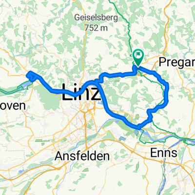
2020 Gallneukirchen nach Maribor
Linz Krems
A cycling route starting in Gallneukirchen, Upper Austria, Austria.
Overview
About this route
- -:--
- Duration
- 141 km
- Distance
- 60 m
- Ascent
- 190 m
- Descent
- ---
- Avg. speed
- 333 m
- Max. altitude

Part of
2020 Gallneukirchen nach Maribor
6 stages
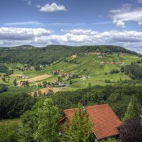
Route photos

Route quality
Waytypes & surfaces along the route
Waytypes
Quiet road
41.6 km
(29 %)
Cycleway
23.6 km
(17 %)
Surfaces
Paved
133.5 km
(95 %)
Unpaved
1.6 km
(1 %)
Asphalt
130.6 km
(93 %)
Concrete
2.4 km
(2 %)
Continue with Bikemap
Use, edit, or download this cycling route
You would like to ride Linz Krems or customize it for your own trip? Here is what you can do with this Bikemap route:
Free features
- Save this route as favorite or in collections
- Copy & plan your own version of this route
- Split it into stages to create a multi-day tour
- Sync your route with Garmin or Wahoo
Premium features
Free trial for 3 days, or one-time payment. More about Bikemap Premium.
- Navigate this route on iOS & Android
- Export a GPX / KML file of this route
- Create your custom printout (try it for free)
- Download this route for offline navigation
Discover more Premium features.
Get Bikemap PremiumFrom our community
Other popular routes starting in Gallneukirchen
 Gallneukirchen-Steyregg-Gallneukirchen
- Distance
- 37.8 km
- Ascent
- 265 m
- Descent
- 263 m
- Location
- Gallneukirchen, Upper Austria, Austria
 Gallneukirchen-Schneebergerstüber-Gallneukirchen
- Distance
- 25 km
- Ascent
- 302 m
- Descent
- 302 m
- Location
- Gallneukirchen, Upper Austria, Austria
 Galli Kirchschlag Gis Linz
- Distance
- 58.2 km
- Ascent
- 1,022 m
- Descent
- 1,022 m
- Location
- Gallneukirchen, Upper Austria, Austria
 In de Hockn
- Distance
- 26.1 km
- Ascent
- 72 m
- Descent
- 188 m
- Location
- Gallneukirchen, Upper Austria, Austria
 Gallneukirchen - Pregarten - Unterweißenbach - Ruben
- Distance
- 55 km
- Ascent
- 982 m
- Descent
- 512 m
- Location
- Gallneukirchen, Upper Austria, Austria
 Gallneukitchen-Abwinden-Ottensheim-Gallneukirchen
- Distance
- 71.3 km
- Ascent
- 193 m
- Descent
- 193 m
- Location
- Gallneukirchen, Upper Austria, Austria
 Galli - Pelmberg - Galli
- Distance
- 33.6 km
- Ascent
- 577 m
- Descent
- 577 m
- Location
- Gallneukirchen, Upper Austria, Austria
 20121014 MTB
- Distance
- 28.9 km
- Ascent
- 759 m
- Descent
- 759 m
- Location
- Gallneukirchen, Upper Austria, Austria
Open it in the app