

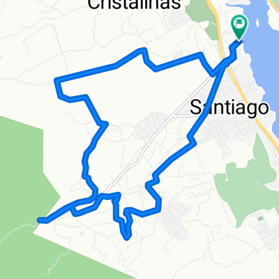
santiago al revés a la taque de agua San Francisco y campanario
A cycling route starting in Santiago, Nuevo León, Mexico.
Overview
About this route
- 2 h 25 min
- Duration
- 16.3 km
- Distance
- 480 m
- Ascent
- 475 m
- Descent
- 6.7 km/h
- Avg. speed
- ---
- Max. altitude

Route quality
Waytypes & surfaces along the route
Waytypes
Quiet road
15.3 km
(94 %)
Road
1 km
(6 %)
Surfaces
Paved
1.8 km
(11 %)
Paved (undefined)
1.6 km
(10 %)
Asphalt
0.2 km
(1 %)
Undefined
14.5 km
(89 %)
Continue with Bikemap
Use, edit, or download this cycling route
You would like to ride santiago al revés a la taque de agua San Francisco y campanario or customize it for your own trip? Here is what you can do with this Bikemap route:
Free features
- Save this route as favorite or in collections
- Copy & plan your own version of this route
- Sync your route with Garmin or Wahoo
Premium features
Free trial for 3 days, or one-time payment. More about Bikemap Premium.
- Navigate this route on iOS & Android
- Export a GPX / KML file of this route
- Create your custom printout (try it for free)
- Download this route for offline navigation
Discover more Premium features.
Get Bikemap PremiumFrom our community
Other popular routes starting in Santiago
 punta la boca cascada de ls brujas
- Distance
- 32.5 km
- Ascent
- 848 m
- Descent
- 851 m
- Location
- Santiago, Nuevo León, Mexico
 punta la boca cerrito y paseo de las brujas a punta morro
- Distance
- 29.5 km
- Ascent
- 577 m
- Descent
- 575 m
- Location
- Santiago, Nuevo León, Mexico
 Calle Infiernillo, Santiago to Calle Infiernillo, Santiago
- Distance
- 15.4 km
- Ascent
- 341 m
- Descent
- 339 m
- Location
- Santiago, Nuevo León, Mexico
 santiago al revés a la taque de agua San Francisco y campanario
- Distance
- 16.3 km
- Ascent
- 480 m
- Descent
- 475 m
- Location
- Santiago, Nuevo León, Mexico
 Punta Morro, comandancia camino de lodo leona cavazos Santiago
- Distance
- 19.5 km
- Ascent
- 422 m
- Descent
- 418 m
- Location
- Santiago, Nuevo León, Mexico
 santiago campanario san fco ligera
- Distance
- 14.4 km
- Ascent
- 264 m
- Descent
- 263 m
- Location
- Santiago, Nuevo León, Mexico
 Leona inversa
- Distance
- 12.9 km
- Ascent
- 274 m
- Descent
- 275 m
- Location
- Santiago, Nuevo León, Mexico
 campanario a san fco piter
- Distance
- 15.4 km
- Ascent
- 363 m
- Descent
- 317 m
- Location
- Santiago, Nuevo León, Mexico
Open it in the app