

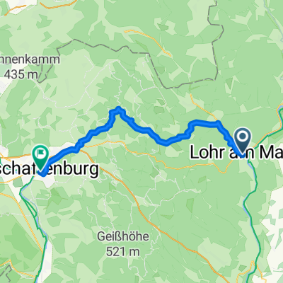
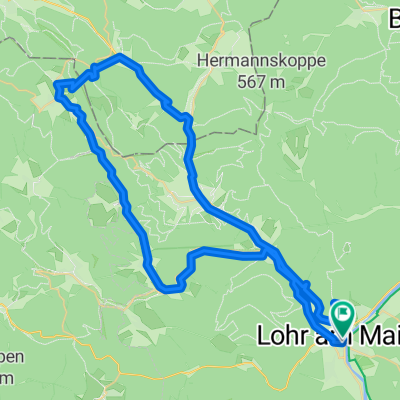
Kupfermühle(Lohr)-Partenstein-HLohrTal
A cycling route starting in Lohr a. Main, Bavaria, Germany.
Overview
About this route
- -:--
- Duration
- 51.2 km
- Distance
- 477 m
- Ascent
- 491 m
- Descent
- ---
- Avg. speed
- ---
- Max. altitude

Route quality
Waytypes & surfaces along the route
Waytypes
Track
23.1 km
(45 %)
Road
14.9 km
(29 %)
Surfaces
Paved
26.1 km
(51 %)
Unpaved
18.4 km
(36 %)
Asphalt
25.6 km
(50 %)
Gravel
17.9 km
(35 %)
Continue with Bikemap
Use, edit, or download this cycling route
You would like to ride Kupfermühle(Lohr)-Partenstein-HLohrTal or customize it for your own trip? Here is what you can do with this Bikemap route:
Free features
- Save this route as favorite or in collections
- Copy & plan your own version of this route
- Sync your route with Garmin or Wahoo
Premium features
Free trial for 3 days, or one-time payment. More about Bikemap Premium.
- Navigate this route on iOS & Android
- Export a GPX / KML file of this route
- Create your custom printout (try it for free)
- Download this route for offline navigation
Discover more Premium features.
Get Bikemap PremiumFrom our community
Other popular routes starting in Lohr a. Main
 Lohr am Main - Beckstein
- Distance
- 86.2 km
- Ascent
- 264 m
- Descent
- 146 m
- Location
- Lohr a. Main, Bavaria, Germany
 Ausfahrt durch Lohr am Main
- Distance
- 27.1 km
- Ascent
- 364 m
- Descent
- 367 m
- Location
- Lohr a. Main, Bavaria, Germany
 Mainradweg Lohr - Bürgstadt
- Distance
- 76.4 km
- Ascent
- 670 m
- Descent
- 699 m
- Location
- Lohr a. Main, Bavaria, Germany
 Kupfermühle(Lohr)-Partenstein-HLohrTal
- Distance
- 51.2 km
- Ascent
- 477 m
- Descent
- 491 m
- Location
- Lohr a. Main, Bavaria, Germany
 Lohr am Main - Aschaffenburg
- Distance
- 46.1 km
- Ascent
- 849 m
- Descent
- 880 m
- Location
- Lohr a. Main, Bavaria, Germany
 11 Ostrunde Lohr
- Distance
- 72.1 km
- Ascent
- 454 m
- Descent
- 454 m
- Location
- Lohr a. Main, Bavaria, Germany
 Von Lohr am Main bis Frammersbacher Forst
- Distance
- 60.5 km
- Ascent
- 1,048 m
- Descent
- 1,046 m
- Location
- Lohr a. Main, Bavaria, Germany
 Johnnys Sommertour 2008, 13.Tag
- Distance
- 153.7 km
- Ascent
- 685 m
- Descent
- 751 m
- Location
- Lohr a. Main, Bavaria, Germany
Open it in the app