

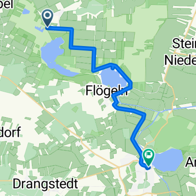
-Flögen- See-Bremerhaven
A cycling route starting in Flögeln, Lower Saxony, Germany.
Overview
About this route
- -:--
- Duration
- 30.4 km
- Distance
- 43 m
- Ascent
- 45 m
- Descent
- ---
- Avg. speed
- ---
- Max. altitude

Route quality
Waytypes & surfaces along the route
Waytypes
Track
12.5 km
(41 %)
Path
7 km
(23 %)
Surfaces
Paved
16.7 km
(55 %)
Unpaved
8.8 km
(29 %)
Asphalt
13.1 km
(43 %)
Gravel
6.7 km
(22 %)
Continue with Bikemap
Use, edit, or download this cycling route
You would like to ride -Flögen- See-Bremerhaven or customize it for your own trip? Here is what you can do with this Bikemap route:
Free features
- Save this route as favorite or in collections
- Copy & plan your own version of this route
- Sync your route with Garmin or Wahoo
Premium features
Free trial for 3 days, or one-time payment. More about Bikemap Premium.
- Navigate this route on iOS & Android
- Export a GPX / KML file of this route
- Create your custom printout (try it for free)
- Download this route for offline navigation
Discover more Premium features.
Get Bikemap PremiumFrom our community
Other popular routes starting in Flögeln
 landfrauentour2018
- Distance
- 37.6 km
- Ascent
- 63 m
- Descent
- 66 m
- Location
- Flögeln, Lower Saxony, Germany
 Holzurburger Straße, Geestland nach Holzurburger Straße, Geestland
- Distance
- 2.1 km
- Ascent
- 4 m
- Descent
- 8 m
- Location
- Flögeln, Lower Saxony, Germany
 Nach Bad Bedakesa
- Distance
- 16 km
- Ascent
- 13 m
- Descent
- 60 m
- Location
- Flögeln, Lower Saxony, Germany
 Flögeln-Steinau-Meck.17,5km
- Distance
- 17.5 km
- Ascent
- 28 m
- Descent
- 20 m
- Location
- Flögeln, Lower Saxony, Germany
 -Flögen- See-Bremerhaven
- Distance
- 30.4 km
- Ascent
- 43 m
- Descent
- 45 m
- Location
- Flögeln, Lower Saxony, Germany
 Test Route1
- Distance
- 77 km
- Ascent
- 29 m
- Descent
- 28 m
- Location
- Flögeln, Lower Saxony, Germany
 Flögeln-Ulm (Milanroute)
- Distance
- 1,029.2 km
- Ascent
- 1,301 m
- Descent
- 791 m
- Location
- Flögeln, Lower Saxony, Germany
 W5 Wanna (CUX 4)
- Distance
- 43 km
- Ascent
- 31 m
- Descent
- 28 m
- Location
- Flögeln, Lower Saxony, Germany
Open it in the app